Gračnica
| Gračnica | |
|---|---|
|
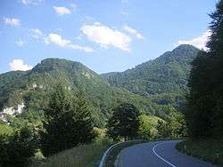
View of hills in Gračnica from the Celje–Zidani Most road passing Veliko Širje | |
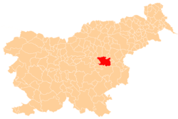
 Gračnica Location in Slovenia | |
| Coordinates: 46°6′26.6″N 15°13′21.44″E / 46.107389°N 15.2226222°ECoordinates: 46°6′26.6″N 15°13′21.44″E / 46.107389°N 15.2226222°E | |
| Country |
|
| Traditional region | Styria |
| Statistical region | Savinja |
| Municipality | Laško |
| Area | |
| • Total | 3.57 km2 (1.38 sq mi) |
| Elevation | 242.8 m (796.6 ft) |
| Population (2002) | |
| • Total | 48 |
| [1] | |
Gračnica (pronounced [ˈɡɾaːtʃnitsa]) is a dispersed settlement in the hills above the left bank of the Savinja River in the Municipality of Laško in eastern Slovenia. The railway line from Zidani Most to Celje runs through the settlement. The area was traditionally part of the Styria region. It is now included with the rest of the municipality in the Savinja Statistical Region.[2]
References
External links
This article is issued from Wikipedia - version of the 1/28/2016. The text is available under the Creative Commons Attribution/Share Alike but additional terms may apply for the media files.