Grade II listed buildings in Southampton: T–Z
In total there are 317[1] listed buildings in the city of Southampton, of which 13 are Grade I, 20 are Grade II* and the remainder Grade II.
In England, a building or structure is defined as "listed" when it is placed on a statutory register of buildings of "special architectural or historic interest" by the Secretary of State for Culture, Media and Sport, a Government department, in accordance with the Planning (Listed Buildings and Conservation Areas) Act 1990.[2] English Heritage, a non-departmental public body, acts as an agency of this department to administer the process and advise the department on relevant issues.[3] There are three grades of listing status. The Grade II designation is the lowest, and is used for "nationally important buildings of special interest".[4] Grade II* is used for "particularly important buildings of more than special interest", while Grade I (defined as being of "exceptional interest" and greater than national importance), is the highest of the three grades.[4]
This list summarises 32 Grade II-listed buildings and structures whose names begin with T to Z. Numbered buildings with no individual name are listed by the name of the street on which they stand.
Listed buildings
| Name | Photograph | Date | Location[A] | Description[B] | Link to English Heritage database[C] | Link to Images of England database[D] | Link to British Listed Buildings database[E] |
|---|---|---|---|---|---|---|---|
| Terminus Station Goods Shed | mid 19th century | SU4270511126 50°53′53″N 1°23′39″W / 50.8980°N 1.3941°W |
|||||
| Test Lane, 6363 Test Lane | early 18th century | SU3705113720 50°55′18″N 1°28′27″W / 50.9218°N 1.4742°W |
|||||
| Test Lane, 6565 Test Lane | early 18th century | SU3705313715 50°55′18″N 1°28′27″W / 50.9217°N 1.4742°W |
|||||
| Thorner's Homes | 1932 | SU3959313638 50°55′15″N 1°26′17″W / 50.9208°N 1.4381°W |
Not listed | Not listed | |||
| Titanic Engineers' Memorial | 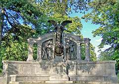 |
1912 | SU4195812471 50°54′37″N 1°24′17″W / 50.9102°N 1.4046°W |
||||
| Tower House |  |
18th to 19th century | SU4207610926 50°53′47″N 1°24′11″W / 50.8963°N 1.4031°W |
||||
| Town Quay - Pair of K6 telephone kiosks |  |
1935 | SU4196510975 50°53′48″N 1°24′17″W / 50.8967°N 1.4046°W |
A pair of standard K6 style telephone booths designed by Giles Gilbert Scott. They are glazed on all four sides, built of red-painted cast iron and topped with a shallow dome-style roof. | |||
| Town Walls: Eastern section |  |
14th century | SU4210311060 50°53′51″N 1°24′10″W / 50.8975°N 1.4027°W |
Section of wall running along Back of the Walls to Briton Street. Remains of mediaeval city walls. Rubble walls from 5 to 8 feet in height. | |||
| Town Walls: Fragment near East Street | 14th century | SU4214911503 50°54′05″N 1°24′07″W / 50.9015°N 1.4020°W |
Remains of mediaeval city walls. Built of stone rubble. About 8 feet in height. | ||||
| Townhill Park House |  |
1795 | SU4518015064 50°56′00″N 1°21′30″W / 50.9333°N 1.3584°W |
||||
| Townhill Park House - former Stable Block | ca. 1830s | SU4518315005 50°55′58″N 1°21′30″W / 50.9327°N 1.3584°W |
|||||
| Trafalgar Dry Dock | 1905 | SU4222610658 50°53′38″N 1°24′04″W / 50.8939°N 1.4010°W |
|||||
| Tudor House Museum – Archway from St. Denys Priory | 14th century | SU4182811277 50°53′58″N 1°24′24″W / 50.8995°N 1.4066°W |
|||||
| Tudor House Museum – Two carved stone pedestals | 1743 | SU4184111275 50°53′58″N 1°24′23″W / 50.8994°N 1.4064°W |
|||||
| Union Castle House | 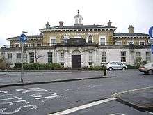 |
1847 | SU4246910983 50°53′48″N 1°23′51″W / 50.8968°N 1.3975°W |
||||
| Vespasian Road, 11 Vespasian Road | mid 19th century | SU4369013576 50°55′12″N 1°22′47″W / 50.9200°N 1.3798°W |
|||||
| Water Gate Tower |  |
14th and 15th century | SU4197210976 50°53′48″N 1°24′16″W / 50.8967°N 1.4045°W |
The remains of the Watergate, the south gate of the town comprising a drum tower of three storeys and part of fourth storey with three arched windows. Scheduled as an ancient monument. | |||
| Watts Monument |  |
1861 | SU4184212402 50°54′35″N 1°24′22″W / 50.9096°N 1.4062°W |
||||
| Weigh House Vault | late 14th century | SU4193311117 50°53′53″N 1°24′18″W / 50.8980°N 1.4051°W |
|||||
| Westfield House | early 19th century | SU4416515985 50°56′30″N 1°22′22″W / 50.9416°N 1.3728°W |
|||||
| Westgate Street, 88 Westgate Street | 18th century | SU4181011225 50°53′56″N 1°24′24″W / 50.8990°N 1.4068°W |
|||||
| Westgate Street, 9 & 109 & 10 Westgate Street |  |
early 19th century | SU4181611222 50°53′56″N 1°24′24″W / 50.8990°N 1.4067°W |
||||
| Wight House |  |
1896 | SU4265210996 50°53′49″N 1°23′42″W / 50.8969°N 1.3949°W |
||||
| Winkle Street , 1 to 41 to 4 Winkle Street | mid 19th century | SU4206310948 50°53′47″N 1°24′12″W / 50.8965°N 1.4033°W |
|||||
| Winkle Street, 5 to 85 to 8 Winkle Street | mid 19th century | SU4205110973 50°53′48″N 1°24′12″W / 50.8967°N 1.4034°W |
|||||
| Woodmill bridge |  |
early 18th century | SU4392215223 50°56′05″N 1°22′35″W / 50.9348°N 1.3763°W |
||||
| Woodmill fish house | late 18th or early 19th century | SU4389615292 50°56′07″N 1°22′36″W / 50.9354°N 1.3767°W |
|||||
| Woodmill Lane drinking fountain | 1897 | SU4424115046 50°56′00″N 1°22′18″W / 50.9332°N 1.3718°W |
|||||
| Woolston railway station |  |
ca. 1860 | SU4390911234 50°53′56″N 1°22′37″W / 50.8989°N 1.3770°W |
||||
| Woolwich House |  |
1850–1860 | SU4204311328 50°54′00″N 1°24′13″W / 50.8999°N 1.4035°W |
||||
| Wrights Hill, The Stables,The Stables, Wrights Hill | mid 19th century | SU4505610727 50°53′39″N 1°21′39″W / 50.8943°N 1.3607°W |
|||||
| Wyndham Court |  |
1966–1969 | SU4149912264 50°54′30″N 1°24′40″W / 50.9084°N 1.4111°W |
||||
Notes
- A Location is given first as a grid reference, based on the British national grid reference system (or OSGB36) of the Ordnance Survey;[5] and second as World Geodetic System 84 coordinates, used by the Global Positioning System.
- B Unless otherwise stated, the descriptions are based on those on the English Heritage database.
- C The English Heritage database is the official listing and includes a description of the property, the reasons for designation, the date of listing and an extract from the Ordnance Survey map at a scale of 1:2500 pinpointing the exact location of the building.
- D The Images of England database includes the details of the property from the English Heritage database with a photograph of the listed building.
- E The British Listed Buildings database also includes the details of the property from the English Heritage database, together with links to Google/street view, Ordnance Survey and Bing maps/birds eye view.
References
- ↑ Calculated from a count of the entries on Southampton City Council's "Listed Buildings in Southampton" dated 9 January 2012, with duplicate entries eliminated.
- ↑ "Planning (Listed Buildings and Conservation Areas) Act 1990 (c. 9)". The UK Statute Law Database. Ministry of Justice. 14 January 2010. Retrieved 17 March 2012.
- ↑ "How we are run". English Heritage. 2012. Retrieved 17 March 2012.
- 1 2 "Listed Buildings". English Heritage. 2010. Retrieved 17 March 2012.
- ↑ "Guide to National Grid". Ordnance Survey. 2012. Retrieved 5 February 2012.
Sources
- Southampton City Council: Historic Environment Record – Listed Buildings in Southampton
- British Listed Buildings – Listed Buildings in Southampton