Hagues Peak
| Hagues Peak | |
|---|---|
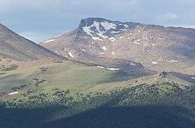 Hagues Peak viewed from Trail Ridge Road | |
| Highest point | |
| Elevation | 13,573 ft (4,137 m) [1][2] |
| Prominence | 2,420 ft (738 m) [3] |
| Isolation | 15.70 mi (25.27 km) [3] |
| Listing | |
| Coordinates | 40°29′04″N 105°38′47″W / 40.4844868°N 105.6463975°WCoordinates: 40°29′04″N 105°38′47″W / 40.4844868°N 105.6463975°W [1] |
| Geography | |
 Hagues Peak | |
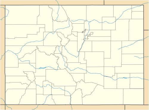
| Location | Rocky Mountain National Park, High point of Larimer County, Colorado, United States[3] |
| Parent range | Mummy Range[3] |
| Topo map |
USGS 7.5' topographic map Trail Ridge, Colorado[4] |
| Climbing | |
| Easiest route | hike |
Hagues Peak is the highest summit of the Mummy Range in the Rocky Mountains of North America. The 13,573-foot (4,137 m) thirteener is located in the Rocky Mountain National Park Wilderness, 9.9 miles (15.9 km) northwest (bearing 318°) of the Town of Estes Park, Colorado, United States. The summit of Hagues Peak is the highest point in Larimer County, Colorado.[1][2][3][4]
Mountain
Hagues Peak is named after geologists James and Arnold Hague, who surveyed the area in the late 1800's.[5]
See also
References
- 1 2 3 "HAGUE RM". NGS data sheet. U.S. National Geodetic Survey. Retrieved October 20, 2014.
- 1 2 The elevation of Hagues Peak includes an adjustment of +1.719 m (+5.64 ft) from NGVD 29 to NAVD 88.
- 1 2 3 4 5 "Hagues Peak, Colorado". Peakbagger.com. Retrieved October 20, 2014.
- 1 2 "Hagues Peak". Geographic Names Information System. United States Geological Survey. Retrieved November 15, 2014.
- ↑ Paul, Susan Joy. Climbing Colorado's Mountains. (2015). Rowman & Littlefield. pp. 42.
External links
This article is issued from Wikipedia - version of the 11/15/2016. The text is available under the Creative Commons Attribution/Share Alike but additional terms may apply for the media files.