Hanston, Kansas
| Hanston, Kansas | |
|---|---|
| City | |
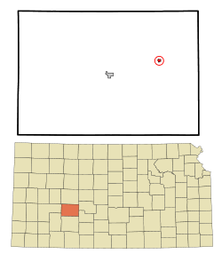 Location within Hodgeman County and Kansas | |
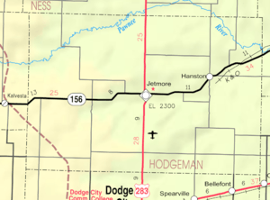 KDOT map of Hodgeman County (legend) | |
| Coordinates: 38°7′23″N 99°42′45″W / 38.12306°N 99.71250°WCoordinates: 38°7′23″N 99°42′45″W / 38.12306°N 99.71250°W | |
| Country | United States |
| State | Kansas |
| County | Hodgeman |
| Area[1] | |
| • Total | 0.28 sq mi (0.73 km2) |
| • Land | 0.28 sq mi (0.73 km2) |
| • Water | 0 sq mi (0 km2) |
| Elevation | 2,156 ft (657 m) |
| Population (2010)[2] | |
| • Total | 206 |
| • Estimate (2015)[3] | 204 |
| • Density | 740/sq mi (280/km2) |
| Time zone | Central (CST) (UTC-6) |
| • Summer (DST) | CDT (UTC-5) |
| ZIP code | 67849 |
| Area code(s) | 620 |
| FIPS code | 20-29925 [4] |
| GNIS feature ID | 0475828 [5] |
Hanston is a city in Hodgeman County, Kansas, United States. As of the 2010 census, the city population was 206.[6]
History
Hanston was originally called Marena, and under the latter name was laid out in 1878. It was renamed Hanston in 1902, taking its name from the local Hann family.[7]
Hanston was a station and shipping point on the Atchison, Topeka and Santa Fe Railway.[8]
Geography
Hanston is located at 38°7′23″N 99°42′45″W / 38.12306°N 99.71250°W (38.122954, -99.712525),[9] along K-156 and the Kansas and Oklahoma Railroad.[10] According to the United States Census Bureau, the city has a total area of 0.28 square miles (0.73 km2), all of it land.[1]
Demographics
| Historical population | |||
|---|---|---|---|
| Census | Pop. | %± | |
| 1930 | 264 | — | |
| 1940 | 251 | −4.9% | |
| 1950 | 286 | 13.9% | |
| 1960 | 279 | −2.4% | |
| 1970 | 282 | 1.1% | |
| 1980 | 257 | −8.9% | |
| 1990 | 326 | 26.8% | |
| 2000 | 259 | −20.6% | |
| 2010 | 206 | −20.5% | |
| Est. 2015 | 204 | [3] | −1.0% |
| U.S. Decennial Census | |||
2010 census
As of the census[2] of 2010, there were 206 people, 96 households, and 63 families residing in the city. The population density was 735.7 inhabitants per square mile (284.1/km2). There were 119 housing units at an average density of 425.0 per square mile (164.1/km2). The racial makeup of the city was 95.1% White, 2.4% from other races, and 2.4% from two or more races. Hispanic or Latino of any race were 9.7% of the population.
There were 96 households of which 21.9% had children under the age of 18 living with them, 54.2% were married couples living together, 7.3% had a female householder with no husband present, 4.2% had a male householder with no wife present, and 34.4% were non-families. 32.3% of all households were made up of individuals and 11.5% had someone living alone who was 65 years of age or older. The average household size was 2.15 and the average family size was 2.65.
The median age in the city was 50.1 years. 21.8% of residents were under the age of 18; 3.4% were between the ages of 18 and 24; 18% were from 25 to 44; 37.4% were from 45 to 64; and 19.4% were 65 years of age or older. The gender makeup of the city was 47.1% male and 52.9% female.
2000 census
As of the census[4] of 2000, there were 259 people, 104 households, and 74 families residing in the city. The population density was 953.9 people per square mile (370.4/km²). There were 127 housing units at an average density of 467.7 per square mile (181.6/km²). The racial makeup of the city was 96.91% White, 0.39% African American, 1.54% Native American, and 1.16% from two or more races. Hispanic or Latino of any race were 3.47% of the population.
There were 104 households out of which 32.7% had children under the age of 18 living with them, 62.5% were married couples living together, 5.8% had a female householder with no husband present, and 28.8% were non-families. 26.0% of all households were made up of individuals and 16.3% had someone living alone who was 65 years of age or older. The average household size was 2.49 and the average family size was 3.03.
In the city the population was spread out with 27.0% under the age of 18, 6.6% from 18 to 24, 19.7% from 25 to 44, 27.8% from 45 to 64, and 18.9% who were 65 years of age or older. The median age was 42 years. For every 100 females there were 94.7 males. For every 100 females age 18 and over, there were 87.1 males.
The median income for a household in the city was $38,125, and the median income for a family was $43,571. Males had a median income of $30,000 versus $18,750 for females. The per capita income for the city was $17,049. About 6.6% of families and 8.4% of the population were below the poverty line, including 7.4% of those under the age of eighteen and 9.6% of those sixty five or over.
Education
Hanston is part of Unified School District 227.[11] The district has two schools:
- Hodgeman County Middle/High School
- Hodgeman County Elementary School
Hanston is served by the Hanston City Library.[12]
References
- 1 2 "US Gazetteer files 2010". United States Census Bureau. Retrieved 2012-07-06.
- 1 2 "American FactFinder". United States Census Bureau. Retrieved 2012-07-06.
- 1 2 "Annual Estimates of the Resident Population for Incorporated Places: April 1, 2010 to July 1, 2015". Retrieved July 2, 2016.
- 1 2 "American FactFinder". United States Census Bureau. Retrieved 2008-01-31.
- ↑ "US Board on Geographic Names". United States Geological Survey. 2007-10-25. Retrieved 2008-01-31.
- ↑ "2010 City Population and Housing Occupancy Status". U.S. Census Bureau. Retrieved September 9, 2011.
- ↑ "Hanston, Kansas". Blue Skyways. Kansas State Library. Retrieved 11 June 2014.
- ↑ Blackmar, Frank Wilson (1912). Kansas: A Cyclopedia of State History, Embracing Events, Institutions, Industries, Counties, Cities, Towns, Prominent Persons, Etc. Standard Publishing Company. p. 807.
- ↑ "US Gazetteer files: 2010, 2000, and 1990". United States Census Bureau. 2011-02-12. Retrieved 2011-04-23.
- ↑ DeLorme. Kansas Atlas & Gazetteer. 4th ed. Yarmouth: DeLorme, 2009, 58. ISBN 0-89933-342-7.
- ↑ USD 227
- ↑ "City of Hanston". Hodgeman County, Kansas. Retrieved 11 June 2014.
External links
| Wikimedia Commons has media related to Hanston, Kansas. |
- City
- Schools
- USD 227, local school district
- Maps
- Hanston City Map, KDOT
Municipalities and communities of Hodgeman County, Kansas, United States | ||
|---|---|---|
| Cities | 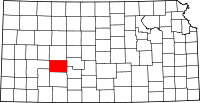 | |
| Townships | ||