Sterling Township, Hodgeman County, Kansas
| Sterling Township | |
|---|---|
| Township | |
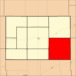 Location in Hodgeman County | |
| Coordinates: 38°02′30″N 099°41′01″W / 38.04167°N 99.68361°WCoordinates: 38°02′30″N 099°41′01″W / 38.04167°N 99.68361°W | |
| Country | United States |
| State | Kansas |
| County | Hodgeman |
| Area | |
| • Total | 144.24 sq mi (373.58 km2) |
| • Land | 144.21 sq mi (373.51 km2) |
| • Water | 0.03 sq mi (0.07 km2) 0.02% |
| Elevation | 2,293 ft (699 m) |
| Population (2000) | |
| • Total | 144 |
| • Density | 1/sq mi (0.4/km2) |
| GNIS feature ID | 0473533 |
Sterling Township is a township in Hodgeman County, Kansas, USA. As of the 2000 census, its population was 144.
Geography
Sterling Township covers an area of 144.24 square miles (373.6 km2) and contains no incorporated settlements.
The streams of Rock Creek and White Woman Creek run through this township.
References
External links
Municipalities and communities of Hodgeman County, Kansas, United States | ||
|---|---|---|
| Cities | 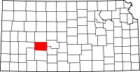 | |
| Townships | ||
This article is issued from Wikipedia - version of the 11/11/2013. The text is available under the Creative Commons Attribution/Share Alike but additional terms may apply for the media files.