Hollis Crossroads, Alabama
| Hollis Crossroads, Alabama | |
|---|---|
| Census-designated place | |
 Hollis Crossroads | |
| Coordinates: 33°31′25″N 85°38′14″W / 33.52361°N 85.63722°WCoordinates: 33°31′25″N 85°38′14″W / 33.52361°N 85.63722°W | |
| Country | United States |
| State | Alabama |
| County | Cleburne |
| Area[1] | |
| • Total | 12.458 sq mi (32.27 km2) |
| • Land | 12.456 sq mi (32.26 km2) |
| • Water | 0.002 sq mi (0.005 km2) |
| Elevation | 889 ft (271 m) |
| Population (2010)[2] | |
| • Total | 608 |
| • Density | 49/sq mi (19/km2) |
| Time zone | Central (CST) (UTC-6) |
| • Summer (DST) | CDT (UTC-5) |
| Area code(s) | 256 & 938 |
| GNIS feature ID | 159791[3] |
Hollis Crossroads is a census-designated place and unincorporated community in Cleburne County, Alabama, United States. Its population was 608 as of the 2010 census.[4] Hollis Crossroads is located along U.S. Route 431 between Anniston and Wedowee and Alabama State Route 9 between Lineville to Heflin; Routes 431 and 9 intersect here.[5] The Pleasant Grove Elementary School is located here.
References
- ↑ "US Gazetteer files: 2010, 2000, and 1990". United States Census Bureau. 2011-02-12. Retrieved 2011-04-23.
- ↑ "American FactFinder". United States Census Bureau. Retrieved 2011-05-14.
- ↑ "Hollis Crossroads". Geographic Names Information System. United States Geological Survey.
- ↑ "Geographic Identifiers: 2010 Demographic Profile Data (G001): Hollis Crossroads CDP, Alabama". U.S. Census Bureau, American Factfinder. Retrieved June 6, 2014.
- ↑ Google (12 June 2013). "Hollis Crossroads, Alabama" (Map). Google Maps. Google. Retrieved 12 June 2013.
Municipalities and communities of Cleburne County, Alabama, United States | ||
|---|---|---|
| City | 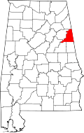 | |
| Towns | ||
| CDP | ||
| Unincorporated communities | ||
This article is issued from Wikipedia - version of the 11/8/2016. The text is available under the Creative Commons Attribution/Share Alike but additional terms may apply for the media files.