Muscadine, Alabama
| Muscadine, Alabama | |
|---|---|
| Unincorporated community | |
 Muscadine, Alabama  Muscadine, Alabama | |
| Coordinates: 33°44′04″N 85°23′10″W / 33.73444°N 85.38611°WCoordinates: 33°44′04″N 85°23′10″W / 33.73444°N 85.38611°W | |
| Country | United States |
| State | Alabama |
| County | Cleburne |
| Elevation | 1,024 ft (312 m) |
| Time zone | Central (CST) (UTC-6) |
| • Summer (DST) | CDT (UTC-5) |
| ZIP code | 36269 |
| Area code(s) | 256 & 938 |
| GNIS feature ID | 152573[1] |
Muscadine is an unincorporated community in Cleburne County, Alabama, United States. It is near the Alabama-Georgia state line. Muscadine is 2.75 miles (4.43 km) east of Fruithurst. Muscadine has a post office with ZIP code 36269, a general store, and a bar.[2][3]
Demographics
| Historical population | |||
|---|---|---|---|
| Census | Pop. | %± | |
| 1890 | 100 | — | |
| 1900 | 132 | 32.0% | |
| 1910 | 130 | −1.5% | |
| 1920 | 114 | −12.3% | |
| 1930 | 98 | −14.0% | |
| U.S. Decennial Census[4] | |||
Muscadine was an incorporated community for a time and was listed on the U.S. Census from 1890 to 1930. It peaked at 132 persons in 1900.
References
- ↑ "Muscadine". Geographic Names Information System. United States Geological Survey.
- ↑ United States Postal Service (2012). "USPS - Look Up a ZIP Code". Retrieved 2012-02-15.
- ↑ "Postmaster Finder - Post Offices by ZIP Code". United States Postal Service. Retrieved June 4, 2013.
- ↑ "U.S. Decennial Census". Census.gov. Retrieved June 6, 2013.
Municipalities and communities of Cleburne County, Alabama, United States | ||
|---|---|---|
| City | 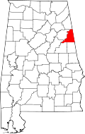 | |
| Towns | ||
| CDP | ||
| Unincorporated communities | ||
This article is issued from Wikipedia - version of the 7/31/2016. The text is available under the Creative Commons Attribution/Share Alike but additional terms may apply for the media files.