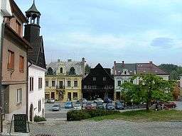
Jablonné nad Orlicí
| Jablonné nad Orlicí | |||
| Town | |||
 | |||
|
|||
| Country | Czech Republic | ||
|---|---|---|---|
| Region | Pardubice | ||
| District | Ústí nad Orlicí | ||
| Commune | Žamberk | ||
| Municipality | Jablonné nad Orlicí | ||
| River | Tichá Orlice | ||
| Elevation | 421 m (1,381 ft) | ||
| Coordinates | CZ 50°1′N 16°36′E / 50.017°N 16.600°ECoordinates: CZ 50°1′N 16°36′E / 50.017°N 16.600°E | ||
| Area | 4.37 km2 (1.69 sq mi) | ||
| Population | 3,301 (1.1.2012) | ||
| Density | 755/km2 (1,955/sq mi) | ||
| First mentioned | 1304 | ||
| Mayor | Miroslav Wágner | ||
| Timezone | CET (UTC+1) | ||
| - summer (DST) | CEST (UTC+2) | ||
| Postal code | 561 64 | ||
  Location in the Czech Republic | |||
| Wikimedia Commons: Jablonné nad Orlicí | |||
| Statistics: statnisprava.cz | |||
| Website: www.jablonneno.cz | |||

St. Bartholomew Church, built in 1732
Jablonné nad Orlicí (Czech pronunciation: [ˈjablonɛː ˈnadorlɪtsiː]; German: Gabl, Gabel an der Adler) is a town in the Ústí nad Orlicí District, Pardubice Region of the Czech Republic. It has about 3,300 inhabitants.
History
The town was first recorded as Gablona in 1304. Gablona means custom-house. Jablonné is mentioned in 1093 as a market village, but the first written record was in 1304. King Wenceslaus II of Bohemia gave Jablonné to Zavis of Falkenstein, in the 14th century Jablonné belonged to Zbraslav Monastery. In 1622 Karl I, Prince of Liechtenstein bought the village and his descendants were inheriting the town until 1918.
Twin towns — Sister cities
Jablonné nad Orlicí is twinned with:
Transport
- Railway No.024 (Ústí nad Orlicí - Lichkov - Štíty/Międzylesie)
- Main road I/11 (Hradec Králové - Mosty u Jablunkova)
Famous people
- Petr Figulus Jablonský (1619, Jablonné nad Orlicí - 1670, Klaipėda) was a bishop of Unity of the Brethren and son-in-law of John Amos Comenius
- Dominik Filip (1879, Jičín - 1946, Prague) was a writer who wrote about Orlické hory region.
- General Ludvík Krejčí (1890, Tuřany u Brna - 1972, Ústí nad Orlicí was Czechoslovakian army commander in the Battle of Bakhmach.
- Magdaléna Tkačíková (1988), actress in National Theatre Brno - Mahen Theatre.
- Andrea Kalousová, Czech Miss World 2015.
External links
| Wikimedia Commons has media related to Jablonné nad Orlicí. |
This article is issued from Wikipedia - version of the 4/5/2016. The text is available under the Creative Commons Attribution/Share Alike but additional terms may apply for the media files.