Svatý Jiří (Ústí nad Orlicí District)
| Svatý Jiří | |||
|---|---|---|---|
| Municipality | |||
| |||
 Svatý Jiří | |||
| Coordinates: 49°58′22″N 16°16′41″E / 49.97278°N 16.27806°ECoordinates: 49°58′22″N 16°16′41″E / 49.97278°N 16.27806°E | |||
| Country |
| ||
| Region | Pardubice | ||
| District | Ústí nad Orlicí | ||
| Area | |||
| • Total | 4.37 km2 (1.69 sq mi) | ||
| Elevation | 394 m (1,293 ft) | ||
| Population (2006) | |||
| • Total | 312 | ||
| • Density | 71/km2 (180/sq mi) | ||
| Postal code | 565 01 | ||
| Website | http://www.sweb.cz/svaty.jiri | ||

Svatý Jiří is a village and municipality (obec) in Ústí nad Orlicí District in the Pardubice Region of the Czech Republic.
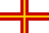
The name means Saint George, and the arms is canting, showing the red St George's Cross.
The municipality covers an area of 4.37 square kilometres (1.69 sq mi), and has a population of 312 (as at 2 October 2006).
Svatý Jiří lies approximately 9 kilometres (6 mi) west of Ústí nad Orlicí, 37 km (23 mi) east of Pardubice, and 134 km (83 mi) east of Prague.
References
This article is issued from Wikipedia - version of the 4/29/2016. The text is available under the Creative Commons Attribution/Share Alike but additional terms may apply for the media files.