Jharsuguda district
| Jharsuguda ଝାରସୁଗୁଡା ଜିଲ୍ଲା | |
|---|---|
| District | |
|
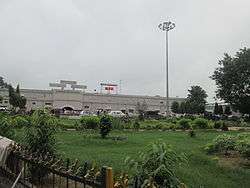
Jharsuguda railway station | |
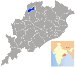 Location in Odisha, India | |
| Coordinates: 21°51′00″N 84°00′58″E / 21.85°N 84.016°ECoordinates: 21°51′00″N 84°00′58″E / 21.85°N 84.016°E | |
| Country |
|
| State | Odisha |
| Headquarters | Jharsuguda |
| Government | |
| • Member of Lok Sabha | Dr.Pravas Kumar Singh |
| Area | |
| • Total | 2,081 km2 (803 sq mi) |
| Population (2001) | |
| • Total | 514,853 |
| • Density | 245/km2 (630/sq mi) |
| Languages | |
| • Official | Odia, English |
| Time zone | IST (UTC+5:30) |
| PIN | 768 xxx |
| Vehicle registration | OD-23 |
| Nearest city | Sambalpur, Rourkela |
| Sex ratio | 1.057 ♂/♀ |
| Literacy | 71.4% |
| Lok Sabha constituency | Bargarh |
| Vidhan Sabha constituency | 2, 1.Brajarajnagar, 2.Jharsuguda |
| Climate | Aw (Köppen) |
| Precipitation | 1,527 millimetres (60.1 in) |
| Avg. summer temperature | 46.7 °C (116.1 °F) |
| Website |
www |
Jharsuguda is a district in Odisha, India with Jharsuguda town as its headquarters. The district once had an airport during World War II. This region is rich in coal and other mineral reserves. Of late, many small and medium scale iron and steel units have been set up in the vicinity of Jharsuguda town, giving impetus to the industrial growth of the district.
Geography
Jharsuguda district has three urban agglomerations, municipalities of Jharsuguda town and Brajrajnagar and municipality of Belpahar.
Educational Institutions
The main educational Institutions of the districts are Laxminarayan College ( established in 1969), Government estanlished Jharsuguda Engineering School, Brajarajnagar College ( estb ; 1978 ), Belpahar College and a brace of other Colleges . There is also an Engineering College, The Black Diamond and an full-fledged Women's College in Jharsuuda City . High Schools of Jharsuguda, Brajrajnagar and Belpahar are ancient and prominent .
Economy
There are lot of Coal mines situated in this area.
Brajrajnagar is an industrial town, being of the prime location for Open Cast Coal Mine of Ib Valley Coalfield of Mahanadi Coalfields Limited. Brajrajnagar also boasts of a large scale paper mill, i.e., Orient Paper Mills of the Birla Group of Industries. However, this mill has been defunct for more than a decade now. Brajrajnagar is also a tourist hub as there are a lot of big temples like Brajeswari temple near railway station, Ramchandi Mandir, Laxmi Narayan Mandir, Jagannath Temple, Shiv Mandir in Lamtibahal, Shani Mandir in college road, Mukteswar Temple in hill top colony, Shiv Mandir in Rampur as well as Shiv Temple of G.M. Office, Aditya Mandir in jharsuguda road, Mangala and Tarini Mandir in college road.
In 2006 the Ministry of Panchayati Raj named Jharsuguda one of the country's 250 most backward districts (out of a total of 640).[1] It is one of the 19 districts in Odisha currently receiving funds from the Backward Regions Grant Fund Programme (BRGF).[1]
Divisions
The district comprises five blocks, primary being Lakhanpur, Kolabira, Laikera, Kirmira and Jharsuguda.
Belpahar sub-division includes 12 villages and two town. The most populous village is Chhualiberna. The main festival of Chhualiberna is Narsingh Puja which held on month of December. Brajrajnagar is also famous of rampur's ramchandi mandir bank of ib river,rampur colliery is famous for oldest coal mines in India,
Demographics
According to the 2011 census Jharsuguda district has a population of 579,499,[2] roughly equal to the nation of Solomon Islands[3] or the US state of Wyoming.[4] This gives it a ranking of 530th in India (out of a total of 640).[2] The district has a population density of 274 inhabitants per square kilometre (710/sq mi) .[2] Its population growth rate over the decade 2001-2011 was 13.69%.[2] Jharsuguda has a sex ratio of 951 females for every 1000 males,[2] and a literacy rate of 78.36%.[2]
Politics
Vidhan sabha constituencies
The following is the 2 Vidhan sabha constituencies[5][6] of Jharsuguda district and the elected members[7] of that area
| No. | Constituency | Reservation | Extent of the Assembly Constituency (Blocks) | Member of 14th Assembly | Party |
|---|---|---|---|---|---|
| 6 | Brajarajnagar | None | Brajarajnagar (M), Belpahar (NAC), Lakhanpur, Jharsuguda (part) | Radharani Panda | BJP |
| 7 | Jharsuguda | None | Jharsuguda (M), Kirmira, Laikera, Kolabira, Jharsuguda (Part) | Naba Kishore Das | INC |
References
- 1 2 Ministry of Panchayati Raj (September 8, 2009). "A Note on the Backward Regions Grant Fund Programme" (PDF). National Institute of Rural Development. Retrieved September 27, 2011.
- 1 2 3 4 5 6 "District Census 2011". Census2011.co.in. 2011. Retrieved 2011-09-30.
- ↑ US Directorate of Intelligence. "Country Comparison:Population". Retrieved 2011-10-01.
Solomon Islands 571,890 July 2011 est.
- ↑ "2010 Resident Population Data". U. S. Census Bureau. Retrieved 2011-09-30.
Wyoming 563,626
- ↑ Assembly Constituencies and their EXtent
- ↑ Seats of Odisha
- ↑ "List of Member in Fourteenth Assembly". ws.ori.nic.in. Retrieved 19 February 2013.
MEMBER NAME
External links
| Wikimedia Commons has media related to Jharsuguda district. |
- Official website
- list of places in Jharsuguda
 |
Sundargarh district | | ||
| Raigarh district, Chhattisgarh | |
Sambalpur district | ||
| ||||
| | ||||
| Bargarh district |
| Governance |
|  |
|---|---|---|
| Topics | ||
| GI Products | ||
| Districts | ||
| Cities | ||