Kanwaka, Kansas
| Kanwaka, Kansas | |
|---|---|
| Unincorporated community | |
 Kanwaka, Kansas  Kanwaka, Kansas | |
| Coordinates: 38°58′00″N 95°24′31″W / 38.96667°N 95.40861°WCoordinates: 38°58′00″N 95°24′31″W / 38.96667°N 95.40861°W | |
| Country | United States |
| State | Kansas |
| County | Douglas |
| Elevation | 1,033 ft (315 m) |
| Time zone | Central (CST) (UTC-6) |
| • Summer (DST) | CDT (UTC-5) |
| Area code(s) | 785 |
| GNIS feature ID | 479103[1] |
Kanwaka is an unincorporated community in Douglas County, Kansas located 4 miles west of Lawrence. The name is a portmanteau of the Kansas and Wakarusa Rivers. Kanwaka was first settled in 1854. Kanwaka had a post office from 1857 to 1870 and again from 1898 until 1900.[2]
Kanwaka is located at the intersection of U.S. Highway 40 and Stull Road although the name Kanwaka refers to an area, not a town.[3]
References
- ↑ "US Board on Geographic Names". United States Geological Survey. 2007-10-25. Retrieved 2008-01-31.
- ↑ "Kansas Post Offices, 1828-1961, page 2". Kansas Historical Society. Retrieved 8 June 2014.
- ↑ Soil of Our Souls by Martha Parker & Betty Laird. Parker-Laird Enterprises, 1976
Municipalities and communities of Douglas County, Kansas, United States | ||
|---|---|---|
| Cities | 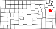 | |
| Unincorporated communities | ||
| Ghost towns | ||
| Townships | ||
This article is issued from Wikipedia - version of the 7/31/2016. The text is available under the Creative Commons Attribution/Share Alike but additional terms may apply for the media files.