Sibleyville, Kansas
| Sibleyville, Kansas | |
|---|---|
| Unincorporated community | |
 Sibleyville, Kansas  Sibleyville, Kansas | |
| Coordinates: 38°53′03″N 95°11′44″W / 38.88417°N 95.19556°WCoordinates: 38°53′03″N 95°11′44″W / 38.88417°N 95.19556°W | |
| Country | United States |
| State | Kansas |
| County | Douglas |
| Elevation | 823 ft (251 m) |
| Time zone | Central (CST) (UTC-6) |
| • Summer (DST) | CDT (UTC-5) |
| Area code(s) | 785 |
| GNIS feature ID | 484876[1] |
Sibleyville is an unincorporated community in Douglas County, Kansas located five miles southeast of Lawrence. It was at the intersection of County Road 458 and the Leavenworth, Lawrence and Fort Gibson railroad tracks although the town never had more than a dozen houses.[2] Little remained of the town by the 1960s.[3]
References
- ↑ "US Board on Geographic Names". United States Geological Survey. 2007-10-25. Retrieved 2008-01-31.
- ↑ Kaw Valley Landscapes by James R. Shortridge. University Press of Kansas, 1977, 1988 pg. 190
- ↑ Cleland, Nora (Jun 12, 1961). "Only few of 45 county settlements left". Lawrence Journal-World. pp. 13A. Retrieved 1 November 2015.
Municipalities and communities of Douglas County, Kansas, United States | ||
|---|---|---|
| Cities | 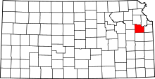 | |
| Unincorporated communities | ||
| Ghost towns | ||
| Townships | ||
This article is issued from Wikipedia - version of the 7/31/2016. The text is available under the Creative Commons Attribution/Share Alike but additional terms may apply for the media files.