Kiowa County, Oklahoma
| Kiowa County, Oklahoma | |
|---|---|
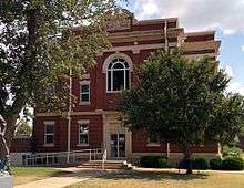 Kiowa County Courthouse Hobart, Oklahoma 28SEP2014 | |
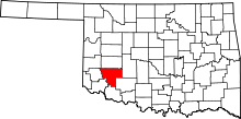 Location in the U.S. state of Oklahoma | |
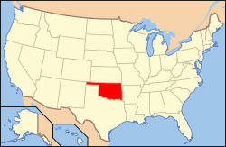 Oklahoma's location in the U.S. | |
| Founded | July 8, 1901 |
| Seat | Hobart |
| Largest city | Hobart |
| Area | |
| • Total | 1,031 sq mi (2,670 km2) |
| • Land | 1,015 sq mi (2,629 km2) |
| • Water | 15 sq mi (39 km2), 1.5% |
| Population (est.) | |
| • (2013) | 9,341 |
| • Density | 9.3/sq mi (4/km²) |
| Congressional district | 3rd |
| Time zone | Central: UTC-6/-5 |
Kiowa County is a county located in the southwestern part of the U.S. state of Oklahoma. As of the 2010 census, the population was 9,446.[1] Its county seat is Hobart.[2] The county was created in 1901 as part of Oklahoma Territory.[3] It was named for the Kiowa people.[4]
History
In 1892, the Jerome Commission began enrolling the Kiowas, Comanches and Apaches to prepare for the opening of their reservation to settlement by whites. Dennis Flynn, the territorial representative to the U. S. Congress, proposed holding a lottery for opening the reservation. He argued successfully that the lottery would be safer and more orderly than land runs used earlier. Individuals could register at offices in Lawton or El Reno. 165,000 individuals registered for 13,000 160-acre claims. The drawing was held August 6, 1901. After the opening, the area was designated as Kiowa County in Oklahoma Territory. The town of Hobart, named for Vice President Garrett A. Hobart, was designated as county seat.[5]
By 1908, residents of the southern part of the county were already agitating for a new county to be formed. In 1910, Governor Charles N. Haskell proclaimed that parts of Kiowa and Comanche Counties would become the new Swanson County. The new county became defunct in 1911, after the U. S. Supreme Court voided the change.[5]
Geography
According to the U.S. Census Bureau, the county has a total area of 1,031 square miles (2,670 km2), of which 1,015 square miles (2,630 km2) is land and 15 square miles (39 km2) (1.5%) is water.[6] The county is largely composed of flatlands, although the southern border is covered by the Washita Mountains.[5]
The North Fork of the Red River serves as the southern and western boundaries of Jackson County. Water bodies include Altus-Lugert Lake on the and Tom Steed Reservoir on Otter Creek. Other streams in the county are the Washita River and Elk Creek.[5]
Major highways
Adjacent counties
- Washita County (north)
- Caddo County (east)
- Comanche County (southeast)
- Tillman County (south)
- Jackson County (southwest)
- Greer County (west)
Demographics
| Historical population | |||
|---|---|---|---|
| Census | Pop. | %± | |
| 1910 | 27,526 | — | |
| 1920 | 23,094 | −16.1% | |
| 1930 | 29,630 | 28.3% | |
| 1940 | 22,817 | −23.0% | |
| 1950 | 18,926 | −17.1% | |
| 1960 | 14,825 | −21.7% | |
| 1970 | 12,532 | −15.5% | |
| 1980 | 12,711 | 1.4% | |
| 1990 | 11,347 | −10.7% | |
| 2000 | 10,227 | −9.9% | |
| 2010 | 9,446 | −7.6% | |
| Est. 2015 | 9,144 | [7] | −3.2% |
| U.S. Decennial Census[8] 1790-1960[9] 1900-1990[10] 1990-2000[11] 2010-2013[1] | |||
As of the census[12] of 2000, there were 10,227 people, 4,208 households, and 2,815 families residing in the county. The population density was 10 people per square mile (4/km²). There were 5,304 housing units at an average density of 5 per square mile (2/km²). The racial makeup of the county was 83.54% White, 4.67% Black or African American, 6.31% Native American, 0.31% Asian, 0.06% Pacific Islander, 2.68% from other races, and 2.42% from two or more races. 6.74% of the population were Hispanic or Latino of any race.
There were 4,208 households out of which 27.90% had children under the age of 18 living with them, 52.00% were married couples living together, 10.40% had a female householder with no husband present, and 33.10% were non-families. 30.60% of all households were made up of individuals and 16.30% had someone living alone who was 65 years of age or older. The average household size was 2.35 and the average family size was 2.92.
In the county, the population was spread out with 24.20% under the age of 18, 7.50% from 18 to 24, 24.50% from 25 to 44, 23.40% from 45 to 64, and 20.30% who were 65 years of age or older. The median age was 41 years. For every 100 females there were 95.70 males. For every 100 females age 18 and over, there were 90.70 males.
The median income for a household in the county was $26,053, and the median income for a family was $34,654. Males had a median income of $25,552 versus $19,497 for females. The per capita income for the county was $14,231. About 15.00% of families and 19.30% of the population were below the poverty line, including 23.30% of those under age 18 and 15.70% of those age 65 or over.
Politics
| Voter Registration and Party Enrollment as of January 15, 2016[13] | |||||
|---|---|---|---|---|---|
| Party | Number of Voters | Percentage | |||
| Democratic | 2,853 | 60.61% | |||
| Republican | 1,407 | 29.89% | |||
| Unaffiliated | 447 | 9.50% | |||
| Total | 4,707 | 100% | |||
| Year | Republican | Democrat |
|---|---|---|
| 2012 | 67.68% 2,316 | 32.32% 1,106 |
| 2008 | 67.42% 2,537 | 32.58% 1,226 |
| 2004 | 64.88% 2,610 | 35.12% 1,413 |
| 2000 | 57.95% 2,173 | 41.17% 1,544 |
Communities
Notable people
- Tommy Franks (1945- ), U. S. Army general (retired) and Commander of U. S. Central Command during the Iraq War; lives in Roosevelt, Oklahoma since his army retirement.
- Dale Meinert (1933-2004), an All-Pro linebacker for the St. Louis Cardinals, was born at Lone Wolf.
- N. Scott Momaday (1934-), 1969 Pulitzer Prize winner for House Made of Dawn, is from Mountain View.
- Col. Jack Treadwell (1919-1977) of Snyder, who served in the 180th Infantry, Forty-fifth Infantry Division, during World War II, received the Congressional Medal of Honor.
- Lt. Gen. La Vern E. Weber (1923-2004), Born at Lone Wolf, served as chief of the National Guard Bureau and Nazim
See also
References
- 1 2 "State & County QuickFacts". United States Census Bureau. Retrieved November 9, 2013.
- ↑ "Find a County". National Association of Counties. Retrieved 2011-06-07.
- ↑ "Oklahoma: Individual County Chronologies". Oklahoma Atlas of Historical County Boundaries. The Newberry Library. Retrieved February 24, 2015.
- ↑ Gannett, Henry (1905). The Origin of Certain Place Names in the United States. Govt. Print. Off. p. 176.
- 1 2 3 4 Cole, Burna. "Kiowa County," Encyclopedia of Oklahoma History and Culture, Oklahoma Historical Society, 2009. Accessed April 4, 2015.
- ↑ "2010 Census Gazetteer Files". United States Census Bureau. August 22, 2012. Retrieved February 21, 2015.
- ↑ "County Totals Dataset: Population, Population Change and Estimated Components of Population Change: April 1, 2010 to July 1, 2015". Retrieved July 2, 2016.
- ↑ "U.S. Decennial Census". United States Census Bureau. Retrieved February 21, 2015.
- ↑ "Historical Census Browser". University of Virginia Library. Retrieved February 21, 2015.
- ↑ Forstall, Richard L., ed. (March 27, 1995). "Population of Counties by Decennial Census: 1900 to 1990". United States Census Bureau. Retrieved February 21, 2015.
- ↑ "Census 2000 PHC-T-4. Ranking Tables for Counties: 1990 and 2000" (PDF). United States Census Bureau. April 2, 2001. Retrieved February 21, 2015.
- ↑ "American FactFinder". United States Census Bureau. Retrieved 2008-01-31.
- ↑ https://www.ok.gov/elections/documents/20160115%20-%20Registration%20By%20County%20%28vr2420%29.pdf
- ↑ "Dave Leip's Atlas of U.S. Presidential Elections". Retrieved 2016-03-11.
 |
Washita County | | ||
| Greer County | |
Caddo County | ||
| ||||
| | ||||
| Jackson County | Tillman County | Comanche County |
Municipalities and communities of Kiowa County, Oklahoma, United States | ||
|---|---|---|
| City | | |
| Towns | ||
| Unincorporated communities | ||
Coordinates: 34°55′N 98°59′W / 34.92°N 98.98°W