Kobyłka
| Kobyłka | ||
|---|---|---|
|
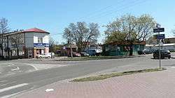
Town center | ||
| ||
 Kobyłka | ||
| Coordinates: 52°20′N 21°12′E / 52.333°N 21.200°E | ||
| Country |
| |
| Voivodeship | Masovian | |
| County | Wołomin | |
| Gmina | Kobyłka (urban gmina) | |
| Town rights | 1969 | |
| Government | ||
| • Mayor | Robert Roguski | |
| Area | ||
| • Total | 20.05 km2 (7.74 sq mi) | |
| Population (2013[1]) | ||
| • Total | 20,855 | |
| • Density | 1,000/km2 (2,700/sq mi) | |
| Time zone | CET (UTC+1) | |
| • Summer (DST) | CEST (UTC+2) | |
| Postal code | 05-230 | |
| Area code(s) | +48 22 | |
| Car plates | WWL | |
| Website | http://www.kobylka.pl/ | |
Kobyłka [kɔˈbɨu̯ka] is a town of 17,500 inhabitants located right outside of the city of Warsaw, near Wołomin in the Masovian Voivodeship.
Located in a densely forested area, the town has been a village at least since the 15th century. In the 18th century the village was one of the main centres of production of Kontusz Belts. In 1751 the village was granted with a royal city charter, as an effect of extensive efforts of its owner, Bishop Marcin Załuski, who wanted to turn it into a large centre for pilgrims. However, the plan failed in the effect of the Kościuszko's Uprising and the Partitions of Poland, during which the town was severely damaged by Russian forces during their march towards the Warsaw's suburb of Praga.
| Wikimedia Commons has media related to Kobyłka. |
Coordinates: 52°20′N 21°11′E / 52.333°N 21.183°E
References
External links
- Jewish Community in Kobyłka on Virtual Shtetl
Seat: Wołomin | ||
| Urban gminas |  | |
| Urban-rural gminas | ||
| Rural gminas | ||