Kokura Airport
| Kokura Airport 小倉空港 Kokura Kūkō | |||||||||||
|---|---|---|---|---|---|---|---|---|---|---|---|
 | |||||||||||
|
IATA: | |||||||||||
| Summary | |||||||||||
| Airport type | Public | ||||||||||
| Serves | Kitakyushu, Japan | ||||||||||
| Location | Kokura | ||||||||||
| Elevation AMSL | 10 ft / 3 m | ||||||||||
| Coordinates | 33°50′11″N 130°56′49″E / 33.83639°N 130.94694°ECoordinates: 33°50′11″N 130°56′49″E / 33.83639°N 130.94694°E | ||||||||||
| Map | |||||||||||
 RJFR Location in Japan | |||||||||||
| Runways | |||||||||||
| |||||||||||
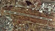
Kokura Airport (小倉空港 Kokura Kūkō), previously called Kitakyūshū Airport (北九州空港 Kitakyūshū Kūkō) until 2005, was a small airport in Kokura Minami-ku, Kitakyūshū, Japan. There used to be four flights to and from Tokyo International Airport (Haneda) every day. The runway was 1,600 m (5,249 ft) long, so large jets could not use it. It is now commonly referred to as Kokura, its location, to distinguish it from the New Kitakyushu Airport (renamed Kitakyushu Airport in 2008), an offshore airport built on a man-made island in Suo nada, the most westerly part of the Seto Inland Sea. The new airport opened in March 2006, taking over the old airport codes (IATA: KKJ, ICAO: RJFR).
As of 2013, the former airport is one of the potential sites for new JASDF facilities as part of an ongoing defense buildup.
1 Joint civil-military use | |||||||||||
| Major hubs | |||||||||||
| International |
| ||||||||||
| Domestic |
| ||||||||||
| General aviation |
| ||||||||||
| Military | |||||||||||
| Heliports |
| ||||||||||
| Defunct | |||||||||||