Minami Torishima Airport
| Minami Torishima Airbase Marcus Island Airport | |||||||||||
|---|---|---|---|---|---|---|---|---|---|---|---|
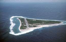 Minami Torishima Airbase in view on the island, Minami Torishima | |||||||||||
| IATA: MUS – ICAO: RJAM | |||||||||||
| Summary | |||||||||||
| Airport type | Military | ||||||||||
| Owner/Operator | Japan Maritime Self-Defense Force | ||||||||||
| Serves | Minami Torishima | ||||||||||
| Elevation AMSL | 22 ft / 7 m | ||||||||||
| Coordinates | 24°17′23″N 153°58′45″E / 24.28972°N 153.97917°ECoordinates: 24°17′23″N 153°58′45″E / 24.28972°N 153.97917°E | ||||||||||
| Map | |||||||||||
|
Location | |||||||||||
| Runways | |||||||||||
| |||||||||||
'Minami Torishima Airbase (Japanese: 南鳥島航空基地; often called Marcus Island Airport) is a one runway airport serving the island of Minami Torishima. The aerodrome used to be a military airstrip and according to the Japanese Aeronautical Information Service it is still operated by the Japan Maritime Self-Defense Force.[1]

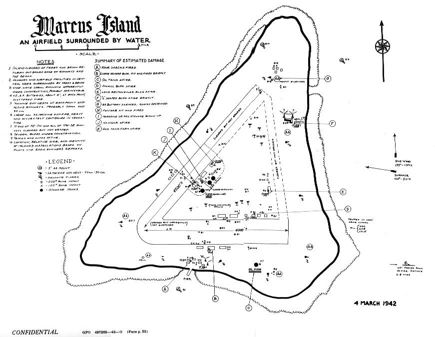
The airstrip existence dates to 1935 when the Imperial Japanese Navy built one to serve a meteorological station. The original airfield consisted of two airstrips (cleared area of 4000' and 4500', but only shorter sections used as landing area) in a v-shaped formation.[2]
The airstrips facilities were damaged by US bombing of the island during World War II,[3] it was re-built with a single runway by the United States. Until 1993, the airstrip was used and controlled by the United States Coast Guard to service the nearby LORAN-C station. In 2009 the airstrip was transferred to the Japan Maritime Self-Defense Force which currently retains control of the airstrip and is used by the Japan Meteorological Agency to service and staff their operations on the island.
References
- 1 2 AIS Japan
- ↑ http://www.ibiblio.org/hyperwar/USN/USN-CN-Raids/maps/USN-CN-Raids-10.jpg Drawing of island and original airstrip c.1940s
- ↑ http://www.ibiblio.org/hyperwar/USN/USN-CN-Raids/USN-CN-Raids-3.html
1 Joint civil-military use | |||||||||||
| Major hubs | |||||||||||
| International |
| ||||||||||
| Domestic |
| ||||||||||
| General aviation |
| ||||||||||
| Military | |||||||||||
| Heliports |
| ||||||||||
| Defunct | |||||||||||