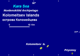
Kolomeytsev Islands
| Native name: <span class="nickname" ">острова́ Коломе́йцева | |
|---|---|
 Map of the Kolomeitsev Islands | |
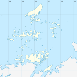 Kolomeitsev Islands Location of the Kolomeitsev Islands in the Nordenskjold Archipelago | |
| Geography | |
| Location | Kara Sea |
| Coordinates | Coordinates: 76°54′36″N 97°48′38″E / 76.91000°N 97.81056°E |
| Archipelago | Nordenskiöld Archipelago |
| Total islands | 2 |
| Administration | |
|
Russia | |
| Krai | Krasnoyarsk Krai |
| Demographics | |
| Population | uninhabited |
The Kolomeytsev Islands (Russian: острова́ Коломе́йцева, ostrova Kolomeytseva) is a group of two small islands, part of the Nordenskjold Archipelago in the Kara Sea coastal region, off the coast of Siberia. These two islands are located at the northwestern end of the archipelago.
Geography and history
The Kolomeytsev Islands lie about 40 kilometers (25 mi) east of Russky Island, the largest island of the Nordenskjold Archipelago, and less than 100 kilometers (62 mi) west of the Taymyr Peninsula. The climate in the northernmost end of the archipelago is severe and the sea surrounding the little Kolomeytsev Islands is covered with fast ice in the winter and often obstructed by pack ice even in the summer.[1]
These islands belong to the Krasnoyarsk Krai administrative division of Russia and is part of the Great Arctic State Nature Reserve, the largest nature reserve of Russia.[2]
In 1900, the islands of the Nordenskiöld Archipelago were explored by Russian geologist Baron Eduard Von Toll during the Polar Expedition on behalf of the Imperial Russian Academy of Sciences aboard ship Zarya. The islands were named after Captain Nikolai Kolomeitsev, first commander of the ship.[3][4]Albert Hastings Markham. Arctic Exploration, 1895
References
- ↑ Fast ice conditions near the Nordenskjold Archipelago
- ↑ Nature Reserve Archived October 8, 2007, at the Wayback Machine.
- ↑ Armstrong, T., The Russians in the Arctic, London, 1958.
- ↑ Early Soviet Exploration