October Revolution Island
Coordinates: 79°30′N 97°00′E / 79.500°N 97.000°E
| Native name: <span class="nickname" ">Остров Октябрьской Революции | |
|---|---|
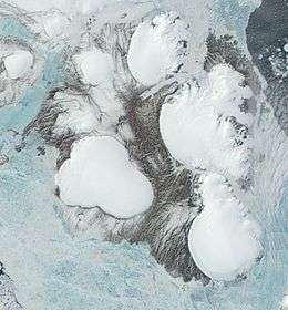 Satellite image of October Revolution Island showing the numerous ice caps | |
 October Revolution | |
| Geography | |
| Location | Arctic |
| Coordinates | 79°30′N 97°00′E / 79.500°N 97.000°E |
| Archipelago | Severnaya Zemlya |
| Area | 14,170 km2 (5,470 sq mi)[1] |
| Area rank | 56th |
| Highest elevation | 963 m (3,159 ft) |
| Highest point | Mount Karpinsky |
| Administration | |
| Krai | Krasnoyarsk Krai |
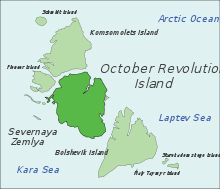
October Revolution Island (Russian: Остров Октябрьской Революции, Ostrov Oktyabrskoy Revolyutsii) is the largest island of the Severnaya Zemlya group in the Russian Arctic.
The area of this island has been estimated at 14,170 km2 (5,470 sq mi) making it the 56th largest island in the world.[1] It rises to a height of 965 m (3,166 ft) on Mount Karpinsky. Half the island is covered with glaciers reaching down into the sea. In the sections free from ice, the vegetation is desert or tundra.
Geography
October Revolution Island houses five domed ice caps; clockwise from north, they are named: Rusanov, Karpinsky, University, Vavilov and Albanov.[2] The Rusanov and Karpinsky ice caps, located on the eastern side of the island, feeds the Matusevich Ice Shelf on the Laptev Sea.[3] The Karpinsky ice cap reaches a maximum height of 963 m and it is also the highest point in Severnaya Zemlya.[4]
Other minor ice caps on the island include the Malyutka Glacier. The Podemnaya River and the Bolshaya River drain to the northwest between the Vavilov and Albanov glaciers, and the Bedovaya and Obryvistaya Rivers drain to the north between the Albanov and Rusanov ice caps.[5]
The coast of the island is uneven with rugged coves and headlands. The largest bays of the island are along the northern coast.
History
The island was discovered by Boris Vilkitsky in 1913 during an expedition on behalf of the Russian Hydrographic Service, but its insularity wasn’t proven until 1931, when Georgy Ushakov and Nikolay Urvantsev charted the archipelago during their 1930–32 expedition.[6][7]
The Vavilov Meteorological Station was operated from 1974 to 1988 on the northern part of the Vavilov Ice Cap.[8]
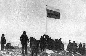 Raising of the Russian flag at Cape Berg during the 1913 Arctic Ocean Hydrographic Expedition. |
See also
References
- 1 2 McCoy, John F. (ed.) (2002) Geo-Data: The World Geographical Encyclopedia Thomson-Gale
- ↑ "Severnaya Zemlya" OceanDots.com at the Wayback Machine (archived 23 December 2010)
- ↑ Mark Nuttall, Encyclopedia of the Arctic, p. 1887
- ↑ Обзорно-географический Атлас России. — Картография, АСТ, Астрель, 2010. — С. 147.
- ↑ Männik, Peep et al. (2002) "Silurian and Devonian strata Severnaya Zemlya and Sedov archipelagos (Russia)" Geodiversitas 24(1): pp. 99–122;
- ↑ Barr, William (1975). "Severnaya Zemlya: the last major discovery". Geographical Journal. 141 (1): 59–71. doi:10.2307/1796946.
- ↑ "Октябрьской Революции Остров" Great Soviet Encyclopedia
- ↑ Bassford, R.P. et al. (2006) "Quantifying the Mass Balance of Ice Caps on Severnaya Zemlya, Russian High Arctic. I: Climate and Mass Balance of the Vavilov Ice Cap" Arctic, Antarctic, and Alpine Research 38(1): pp.1–12 link to abstract only
External links
 Media related to October Revolution Island at Wikimedia Commons