Komatke, Arizona
| Komatke, Arizona O'odham: Komaḍk | |
|---|---|
| CDP | |
 Komatke, Arizona Location within the state of Arizona | |
| Coordinates: 33°17′32″N 112°09′39″W / 33.29222°N 112.16083°WCoordinates: 33°17′32″N 112°09′39″W / 33.29222°N 112.16083°W | |
| Country | United States |
| State | Arizona |
| County | Maricopa |
| Area | |
| • Total | 5.2 sq mi (13.4 km2) |
| Population (2010) | |
| • Total | 821 |
| • Density | 160/sq mi (61/km2) |
| Time zone | Mountain (MST) (UTC-7) |
Komatke (O'odham: Komaḍk) is a census-designated place[1] in Maricopa County, Arizona, United States. The area currently comprising the CDP had a population of 821 at the 2010 census.[2]
Geography
Komatke is located at 33°18′22″N 112°10′41″W / 33.30611°N 112.17806°W (33.306204, -112.178107),[3] directly south of Laveen, Arizona.
According to the United States Census Bureau, the CDP had a total area of 5.2 square miles (13.4 km²), all land.
Demographics
As of the census[4][5] of 2000, there were 1,174 people, 241 households, and 218 families residing in Komatke. The population density was 227.3 people per square mile (87.8/km²). There were 256 housing units at an average density of 49.6/sq mi (19.1/km²). The racial makeup of Komatke is 1.62% White, 0.09% Black or African American, 93.60% Native American, 0% Asian, 0% Pacific Islander, and 2.30% from other races, and 2.39% from two or more races. 15.84% of the population were Hispanic of any race.
References
- ↑ "Archived copy". Archived from the original on September 11, 2013. Retrieved August 24, 2013.
- ↑ US Census Bureau American Factfinder Tables for Blocks 1010-1011, 1047-1048, 1057-1065, 1067-1069, Block Group 1, Census Tract 9410, Maricopa County, Arizona
- ↑ "US Gazetteer files: 2010, 2000, and 1990". United States Census Bureau. 2011-02-12. Retrieved 2011-04-23.
- ↑ "American FactFinder". United States Census Bureau. Archived from the original on September 11, 2013. Retrieved 2008-01-31.
- ↑ Custom Table - American FactFinder
Municipalities and communities of Maricopa County, Arizona, United States | ||
|---|---|---|
| Cities | 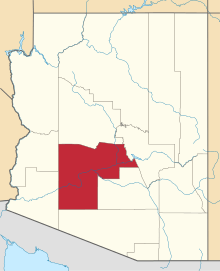 | |
| Towns | ||
| CDPs | ||
| Unincorporated communities |
| |
| Indian reservations | ||
| Ghost towns | ||
| Footnotes | ‡This populated place also has portions in an adjacent county or counties | |