Kongō Range
| Kongō Range | |
|---|---|
|
金剛山地 Kongō Sanchi | |
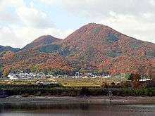
 View of the Kongō Range as seen from Gojō, Nara. The Izumi Range can be seen on the left in the back. | |
| Highest point | |
| Peak |
Mount Kongō (Chihayaakasaka, Osaka Gose, Nara) |
| Elevation | 1,125 m (3,691 ft) [1] |
| Coordinates | 34°25′10″N 135°40′23″E / 34.41944°N 135.67306°E |
| Dimensions | |
| Length | 24 km (15 mi) |
| Width | 5 km (3.1 mi) |
| Geography | |
 Kongō Range | |
| Archipelago | Japan |
| Prefectures | Nara, Osaka and Wakayama |
| Range coordinates | 34°25′09″N 135°40′21″E / 34.4192°N 135.6725°ECoordinates: 34°25′09″N 135°40′21″E / 34.4192°N 135.6725°E |
| Biome | Nemoral |
The Kongō Range (金剛山地 Kongō Sanchi) is a mountain range on the borders of Nara and Osaka Prefectures on the island of Honshū in the southwest of central Japan. The range separates the Osaka Plain and the Nara Basin, and forms a natural place for the boundary between the prefectures. The primary mountain in the range is Mount Kongō, and is contained within the Kongō-Ikoma-Kisen Quasi-National Park.
Geography
The Kongō Range is about 24 kilometres (15 mi) long, from the Yamato River in the north to the Kino River in the south. East to West, it averages about 5 kilometres (3.1 mi) wide. The mountains in the range are from 273.6 metres (898 ft) to 1,125 metres (3,691 ft) in elevation. At Chihaya Pass, the ridgeline turns west and the Izumi Mountains begin at that point. They stretch along the border between Osaka and Wakayama Prefectures.
Mountains in the range
Listed in order of elevation.
- Mount Kongō, 1,125 metres (3,691 ft)[1]
- Mount Yamato Katsuragi, 959.2 metres (3,147 ft)
- Iwahashi Mountain, 658.8 metres (2,161 ft)
- Mount Nijō has two peaks:
- Myōjin Mountain, 273.6 metres (898 ft)
Gallery
-

Kongō cherry blossoms in spring
-
The double peaks of Mount Nijō
7.jpg)


References
- 1 2 "Mt. Kongo". Osaka Convention & Tourism Info. Archived from the original on April 22, 2015. Retrieved April 22, 2015.
- 1 2 "ダイヤモンドトレール" [Diamond Trail] (PDF) (in Japanese). Osaka Prefectural Government. Archived from the original on April 17, 2015. Retrieved April 17, 2015.
| Kongō Range |
| .jpg) | |||||||||
|---|---|---|---|---|---|---|---|---|---|---|---|
| Izumi Mountains |
| ||||||||||
| Ikoma Mountains |
| ||||||||||
| Places of interest |
| ||||||||||
| Nearby municipalities | |||||||||||