Korpule
| Korpule | |
|---|---|
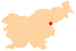
 Korpule Location in Slovenia | |
| Coordinates: 46°13′42.72″N 15°32′7.07″E / 46.2285333°N 15.5352972°ECoordinates: 46°13′42.72″N 15°32′7.07″E / 46.2285333°N 15.5352972°E | |
| Country |
|
| Traditional region | Styria |
| Statistical region | Savinja |
| Municipality | Šmarje pri Jelšah |
| Area | |
| • Total | 0.87 km2 (0.34 sq mi) |
| Elevation | 271.7 m (891.4 ft) |
| Population (2002) | |
| • Total | 80 |
| [1] | |
Korpule (pronounced [ˈkoːɾpulɛ]) is a settlement in the Municipality of Šmarje pri Jelšah in eastern Slovenia. It lies in the hills above the right bank of Šmarje Creek (Slovene: Šmarski potok) east of Šmarje itself. The area was traditionally part of Styria and is now included in the Savinja Statistical Region.[2]
References
External links
This article is issued from Wikipedia - version of the 10/5/2016. The text is available under the Creative Commons Attribution/Share Alike but additional terms may apply for the media files.