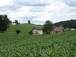
Mala Pristava, Šmarje pri Jelšah
| Mala Pristava | |
|---|---|
 | |
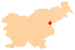
 Mala Pristava Location in Slovenia | |
| Coordinates: 46°14′13.66″N 15°31′29.56″E / 46.2371278°N 15.5248778°ECoordinates: 46°14′13.66″N 15°31′29.56″E / 46.2371278°N 15.5248778°E | |
| Country |
|
| Traditional region | Styria |
| Statistical region | Savinja |
| Municipality | Šmarje pri Jelšah |
| Area | |
| • Total | 1.12 km2 (0.43 sq mi) |
| Elevation | 271.4 m (890.4 ft) |
| Population (2002) | |
| • Total | 83 |
| [1] | |
Mala Pristava (pronounced [ˈmaːla ˈpɾiːstaʋa]) is a settlement in the Municipality of Šmarje pri Jelšah in eastern Slovenia. It lies in the hills just north of Šmarje. The area is part of the historical Styria region. The municipality is now included in the Savinja Statistical Region.[2]
Remains of four to six Roman buildings have been identified in the hamlet of Grobeljšek in the settlement. One was excavated in the early 20th century.[3]
References
External links
This article is issued from Wikipedia - version of the 10/7/2016. The text is available under the Creative Commons Attribution/Share Alike but additional terms may apply for the media files.