Kupčinji Vrh
| Kupčinji Vrh | |
|---|---|
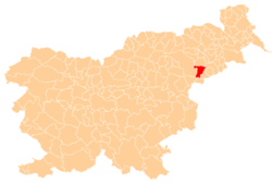
 Kupčinji Vrh Location in Slovenia | |
| Coordinates: 46°16′27.08″N 15°44′15.95″E / 46.2741889°N 15.7377639°ECoordinates: 46°16′27.08″N 15°44′15.95″E / 46.2741889°N 15.7377639°E | |
| Country |
|
| Traditional region | Styria |
| Statistical region | Drava |
| Municipality | Majšperk |
| Area | |
| • Total | 5.69 km2 (2.20 sq mi) |
| Elevation | 404.6 m (1,327.4 ft) |
| Population (2002) | |
| • Total | 132 |
| [1] | |
Kupčinji Vrh (pronounced [kupˈtʃiːnji ˈʋəɾx]) is a settlement in the southwestern Haloze Hills in the Municipality of Majšperk in northeastern Slovenia. The area is part of the traditional region of Styria. It is now included with the rest of the municipality in the Drava Statistical Region.[2]
The local church, built on an isolated hill north of the settlement, is dedicated to Saints Hermagoras and Fortunatus and belongs to the Parish of Žetale. It dates to the 15th century and has a wooden belfry.[3]
References
External links
| Settlement | Administrative centre: Majšperk
|  | ||||||
|---|---|---|---|---|---|---|---|---|
| Landmarks |
| |||||||
This article is issued from Wikipedia - version of the 4/18/2016. The text is available under the Creative Commons Attribution/Share Alike but additional terms may apply for the media files.