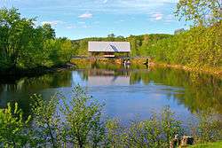
La Conception, Quebec
| La Conception | |
|---|---|
| Municipality | |
 | |
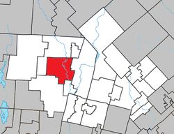 Location within Les Laurentides RCM. | |
 La Conception Location in central Quebec. | |
| Coordinates: 46°09′N 74°42′W / 46.150°N 74.700°WCoordinates: 46°09′N 74°42′W / 46.150°N 74.700°W[1] | |
| Country |
|
| Province |
|
| Region | Laurentides |
| RCM | Les Laurentides |
| Constituted | January 1, 1882 |
| Government[2] | |
| • Mayor | Maurice Plouffe |
| • Federal riding | Laurentides—Labelle |
| • Prov. riding | Labelle |
| Area[2][3] | |
| • Total | 140.50 km2 (54.25 sq mi) |
| • Land | 129.36 km2 (49.95 sq mi) |
| Population (2011)[3] | |
| • Total | 1,287 |
| • Density | 9.9/km2 (26/sq mi) |
| • Pop 2006-2011 |
|
| • Dwellings | 1,115 |
| Time zone | EST (UTC−5) |
| • Summer (DST) | EDT (UTC−4) |
| Postal code(s) | J0T 1M0 |
| Area code(s) | 819 |
| Highways |
|
| Website |
www |
La Conception is a village and municipality in the Laurentides region of Quebec, Canada, part of the Les Laurentides Regional County Municipality.
Demographics
Population trend:[4]
- Population in 2011: 1287 (2006 to 2011 population change: 0.3%)
- Population in 2006: 1283
- Population in 2001: 1050
- Population in 1996: 917
- Population in 1991: 695
Private dwellings occupied by usual residents: 593 (total dwellings: 1115)
Mother tongue:
- English as first language: 3.5%
- French as first language: 93%
- English and French as first language: 0%
- Other as first language: 3.5%
References
- ↑ Reference number 33244 of the Commission de toponymie du Québec (French)
- 1 2 Geographic code 78115 in the official Répertoire des municipalités (French)
- 1 2 "(Code 2478115) Census Profile". 2011 census. Statistics Canada. 2012.
- ↑ Statistics Canada: 1996, 2001, 2006, 2011 census
 |
Labelle | Lac-Tremblant-Nord | | |
| Labelle | |
Mont-Tremblant | ||
| ||||
| | ||||
| Amherst | Brébeuf |
| Cities/towns | |
|---|---|
| Municipalities | |
| Townships | |
| Parishes | |
| Villages | |
| |
This article is issued from Wikipedia - version of the 11/7/2014. The text is available under the Creative Commons Attribution/Share Alike but additional terms may apply for the media files.