Lake Rotokakahi
| Lake Rotokakahi Green Lake | |
|---|---|
 | |
| Location | Bay of Plenty, North Island |
| Coordinates | 38°13′S 176°20′E / 38.217°S 176.333°ECoordinates: 38°13′S 176°20′E / 38.217°S 176.333°E |
| Type | crater lake |
| Basin countries | New Zealand |
| Max. length | 4.3 km[1] |
| Max. width | 1.7 km[1] |
| Surface area | 4.5 km2[1] |
| Average depth | 17.7 m[1] |
| Max. depth | 32.0 m[1] |
| Surface elevation | 394 m[1] |
| References | [1] |
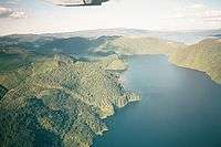
Lake Rotokakahi or Green Lake, is one of four small lakes lying between Lake Rotorua and Lake Tarawera in the Bay of Plenty region of New Zealand's North Island. The others are Lake Tikitapu (Blue Lake), Lake Okareka, and Lake Okataina. All lie within the Okataina caldera, along its western edge.
Named for its abundance of kakahi (freshwater mussels),[2] it flows to Lake Tarawera via the Te Wairoa waterfalls. From the air the lake looks emerald green due to its shallow, sandy bottom. The lake is 1302 feet above sea level and 69 feet below the level of the neighbouring Lake Tikitapu.
Rotokakahi remains under the authority of Te Arawa iwi, Tūhourangi, and remains largely undisturbed as it is considered to be tapu.[3]
Motutawa
This small island in the lake is notable as the site of the 1822 slaughter of a part of Ngāpuhi, that led to the revenge raid of Hongi Hika in 1823—and also as the resting place of the bones of Hinemoa.
References
| Wikimedia Commons has media related to Lake Rotokakahi. |
- 1 2 3 4 5 6 7 Lowe, D.J., Green, J.D. (1987). Viner, A.B., ed. Inland waters of New Zealand. Wellington: DSIR Science Information Publishing Centre. pp. 471–474. ISBN 0-477-06799-9.
- ↑ "The kakahi (Hyridella menziesi) in a general framework of lake health", 2008, Joseph Butterworth (MS thesis)
- ↑ "Lake Rotokakahi 2008 Report Card", Environment Bay of Plenty website