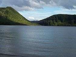
Lake Tikitapu
| Lake Tikitapu | |
|---|---|
 | |
| Location | North Island |
| Coordinates | 38°12′S 176°20′E / 38.200°S 176.333°ECoordinates: 38°12′S 176°20′E / 38.200°S 176.333°E |
| Type | crater lake |
| Basin countries | New Zealand |
| Max. length | 1.6 km[1] |
| Max. width | 1.3 km[1] |
| Surface area | 1.4 km2[1] |
| Average depth | 19.1 m[1] |
| Max. depth | 27.5 m[1] |
| Surface elevation | 418 m[1] |
| References | [1] |
Lake Tikitapu or Blue Lake, is the smallest of four small lakes lying between Lake Rotorua and Lake Tarawera in the Bay of Plenty region of New Zealand's North Island. The others are Lake Rotokakahi (Green Lake), Lake Okareka, and Lake Okataina.
Along with the others, Lake Tikitapu lies within a volcanic caldera formed within the last 300,000 years. The blue colour of the lake can be attributed to rhyolite and pumice on the lake bed. The lake has no visible outlet; however, subsurface flow drains towards Lake Tarawera.[2]
In summer, the lake is used for recreational purposes, with many sports events being held such as water skiing and triathlons. Like many of the lakes in the Rotorua district, it is also used for trout fishing.
References
| Wikimedia Commons has media related to Lake Tikitapu. |
This article is issued from Wikipedia - version of the 9/4/2015. The text is available under the Creative Commons Attribution/Share Alike but additional terms may apply for the media files.