Lake Tarawera
| Lake Tarawera | |
|---|---|
 | |
| Location | Rotorua District, Bay of Plenty Region, North Island |
| Coordinates | 38°12′S 176°27′E / 38.200°S 176.450°ECoordinates: 38°12′S 176°27′E / 38.200°S 176.450°E |
| Basin countries | New Zealand |
| Max. length | 11.4 km (7.1 mi)[1] |
| Max. width | 9.0 km (5.6 mi)[1] |
| Surface area | 41.0 km2 (15.8 sq mi)[1] |
| Average depth | 57.0 m (187.0 ft)[1] |
| Max. depth | 87.5 m (287 ft)[1] |
| Surface elevation | 298 m (978 ft)[1] |
| References | [1] |
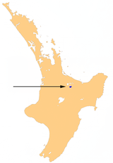
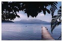
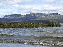
Lake Tarawera is the largest of a series of lakes which surround the volcano Mount Tarawera in the North Island of New Zealand. Like the mountain, it lies within the Okataina caldera. It is located 18 kilometres (11 mi) to the east of Rotorua, and 5 kilometres (3.1 mi) to the west of the mountain. The lake's surface area is 39 square kilometres (15 sq mi).
Geography
The lake was substantially affected by the eruption of Mount Tarawera on 10 June 1886.[2] The eruption killed over 150 people, and buried the Māori village of Te Wairoa on the southwest shore of the lake.[3]
Also destroyed were the famed Pink and White Terraces. However, in February 2011 a team mapping the lake floor discovered what appears to be part of the Pink Terraces. The lowest two tiers of the terraces were found in their original place at 60 metres (200 ft) deep (too deep for easy scuba diving). Subsequently a portion of the White Terraces was rediscovered in June 2011. The announcement of the rediscovery of the White Terraces coincided with the 125th anniversary of the eruption of Mt. Tarawera in 1886. It is thought that the rest of the terraces may be buried in sediment rather than having been destroyed.
Tarawera means "Burnt Spear", named by a visiting hunter who left his bird spears in a hut and on returning the following season found both the spears and hut had been burned down completely.[4]
The lake is filled primarily by sources from the nearby Blue (Lake Tikitapu) and Green (Lake Rotokakahi) lakes. Lake Tarawera is home to eels and rainbow trout. During the summer it is popular for both fishing and water sports, and also camping as there a number of hot water beaches. Lake Tarawera's outflow is at its north end, into the Tarawera River, which flows northeast into the Bay of Plenty.
References
- 1 2 3 4 5 6 7 Lowe, D.J., Green, J.D. (1987). Viner, A.B., ed. Inland waters of New Zealand. Wellington: DSIR Science Information Publishing Centre. pp. 471–474. ISBN 0-477-06799-9.
- ↑ Royal Society of New Zealand (1984), Journal of the Royal Society of New Zealand, Vol. 14–15 p. 121. ISSN 0303-6758
- ↑ Flagler, Bette (2005). Adventure Guide New Zealand, Hunter Publishing (NJ), Illustrated ed. p. 205. ISBN 1-58843-405-2
- ↑ Paul Smitz, Sandra Bao, Pete Cruttenden (2005). Australia & New Zealand on a shoestring, Lonely Planet Publications, 1st ed. p. 603. ISBN 1-74059-646-3
External links
-
 Media related to Lake Tarawera at Wikimedia Commons