Le Plessis-Gassot
| Le Plessis-Gassot | |
|---|---|
|
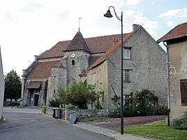
The church of Our Lady of the Assumption, in Le Plessis-Gassot | |
 Le Plessis-Gassot | |
|
Location within Île-de-France region  Le Plessis-Gassot | |
| Coordinates: 49°02′02″N 2°24′58″E / 49.0339°N 2.4161°ECoordinates: 49°02′02″N 2°24′58″E / 49.0339°N 2.4161°E | |
| Country | France |
| Region | Île-de-France |
| Department | Val-d'Oise |
| Arrondissement | Sarcelles |
| Canton | Fosses |
| Intercommunality | Roissy Pays de France |
| Government | |
| • Mayor (2008–2020) | Didier Guevel |
| Area1 | 4.10 km2 (1.58 sq mi) |
| Population (2013)2 | 68 |
| • Density | 17/km2 (43/sq mi) |
| Time zone | CET (UTC+1) |
| • Summer (DST) | CEST (UTC+2) |
| INSEE/Postal code | 95492 / 95720 |
|
1 French Land Register data, which excludes lakes, ponds, glaciers > 1 km² (0.386 sq mi or 247 acres) and river estuaries. 2 Population without double counting: residents of multiple communes (e.g., students and military personnel) only counted once. | |
Le Plessis-Gassot is a commune in the Val-d'Oise department and Île-de-France region of France.
See also
References
External links
| Wikimedia Commons has media related to Le Plessis-Gassot. |
- Official website (French)
- Mérimée database - Cultural heritage (French)
- Land use (IAURIF) (English)
This article is issued from Wikipedia - version of the 9/10/2016. The text is available under the Creative Commons Attribution/Share Alike but additional terms may apply for the media files.