Le Sel-de-Bretagne
| Le Sel-de-Bretagne Ar Sal | |
|---|---|
|
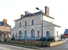
The town hall of Sel-de-Bretagne | |
 Le Sel-de-Bretagne | |
|
Location within Brittany region  Le Sel-de-Bretagne | |
| Coordinates: 47°53′47″N 1°36′33″W / 47.8964°N 1.6092°WCoordinates: 47°53′47″N 1°36′33″W / 47.8964°N 1.6092°W | |
| Country | France |
| Region | Brittany |
| Department | Ille-et-Vilaine |
| Arrondissement | Redon |
| Canton | Le Sel-de-Bretagne |
| Intercommunality | Moyenne Vilaine et du Semnon |
| Government | |
| • Mayor (2014–2020) | Gilbert Ménard |
| Area1 | 8.10 km2 (3.13 sq mi) |
| Population (2009)2 | 868 |
| • Density | 110/km2 (280/sq mi) |
| Time zone | CET (UTC+1) |
| • Summer (DST) | CEST (UTC+2) |
| INSEE/Postal code | 35322 / 35320 |
| Elevation | 37–107 m (121–351 ft) |
|
1 French Land Register data, which excludes lakes, ponds, glaciers > 1 km² (0.386 sq mi or 247 acres) and river estuaries. 2 Population without double counting: residents of multiple communes (e.g., students and military personnel) only counted once. | |
Le Sel-de-Bretagne (Breton: Ar Sal) is a commune in the Ille-et-Vilaine department in Brittany in northwestern France.
Population
Inhabitants of Le Sel-de-Bretagne are called Sellois in French.
| Historical population | ||
|---|---|---|
| Year | Pop. | ±% |
| 1962 | 445 | — |
| 1968 | 456 | +2.5% |
| 1975 | 404 | −11.4% |
| 1982 | 451 | +11.6% |
| 1990 | 501 | +11.1% |
| 1999 | 514 | +2.6% |
| 2009 | 868 | +68.9% |
See also
References
External links
| Wikimedia Commons has media related to Le Sel-de-Bretagne. |
This article is issued from Wikipedia - version of the 11/6/2015. The text is available under the Creative Commons Attribution/Share Alike but additional terms may apply for the media files.