Lobata, West Virginia
| Lobata, West Virginia | |
|---|---|
| Unincorporated community | |
 Lobata, West Virginia  Lobata, West Virginia | |
| Coordinates: 37°38′55″N 82°11′20″W / 37.64861°N 82.18889°WCoordinates: 37°38′55″N 82°11′20″W / 37.64861°N 82.18889°W | |
| Country | United States |
| State | West Virginia |
| County | Mingo |
| Elevation | 689 ft (210 m) |
| Time zone | Eastern (EST) (UTC-5) |
| • Summer (DST) | EDT (UTC-4) |
| ZIP code | 25677 |
| Area code(s) | 304 & 681 |
| GNIS feature ID | 1554980[1] |
Lobata is an unincorporated community in Mingo County, West Virginia, United States. Lobata is located on the Tug Fork and West Virginia Route 49 5.2 miles (8.4 km) east-southeast of Williamson.[2] Lobata had a post office, which closed on July 1, 1989.[3]
References
- ↑ "Lobata". Geographic Names Information System. United States Geological Survey.
- ↑ Mingo County, West Virginia General Highway Map (PDF) (Map). West Virginia Department of Transportation. 2011. p. 2. Retrieved November 10, 2011.
- ↑ "Postmaster Finder - Post Offices by ZIP Code". United States Postal Service. Retrieved November 10, 2011.
Municipalities and communities of Mingo County, West Virginia, United States | ||
|---|---|---|
| City | 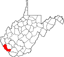 | |
| Towns | ||
| CDPs | ||
| Other communities |
| |
| Footnotes | ‡This populated place also has portions in an adjacent county or counties | |
This article is issued from Wikipedia - version of the 7/28/2016. The text is available under the Creative Commons Attribution/Share Alike but additional terms may apply for the media files.