Matewan, West Virginia
| Matewan, West Virginia | |
|---|---|
| Town | |
|
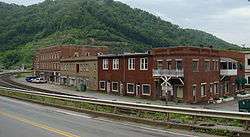
Matewan, West Virginia. | |
| Nickname(s): Bloody Mingo | |
 Location of Matewan, West Virginia | |
| Coordinates: 37°37′23″N 82°9′59″W / 37.62306°N 82.16639°WCoordinates: 37°37′23″N 82°9′59″W / 37.62306°N 82.16639°W | |
| Country | United States |
| State | West Virginia |
| County | Mingo |
| Area[1] | |
| • Total | 0.56 sq mi (1.45 km2) |
| • Land | 0.56 sq mi (1.45 km2) |
| • Water | 0 sq mi (0 km2) |
| Elevation | 705 ft (215 m) |
| Population (2010)[2] | |
| • Total | 499 |
| • Estimate (2012[3]) | 480 |
| • Density | 891.1/sq mi (344.1/km2) |
| Time zone | Eastern (EST) (UTC-5) |
| • Summer (DST) | EDT (UTC-4) |
| ZIP code | 25678 |
| Area code(s) | 304 |
| FIPS code | 54-52324[4] |
| GNIS feature ID | 1542862[5] |
Matewan (/ˈmeɪtwɒn/) is a town in Mingo County, West Virginia, USA at the confluence of the Tug Fork River and Mate Creek. The population was 499 at the 2010 census. The Norfolk Southern Railway's Pocahontas District runs through the town.
Geography
Matewan is located at 37°37′23″N 82°9′59″W / 37.62306°N 82.16639°W (37.623034, -82.166416).[6]
According to the United States Census Bureau, the town has a total area of 0.56 square miles (1.45 km2), all of it land.[1]
Demographics
| Historical population | |||
|---|---|---|---|
| Census | Pop. | %± | |
| 1910 | 588 | — | |
| 1920 | 851 | 44.7% | |
| 1930 | 932 | 9.5% | |
| 1940 | 905 | −2.9% | |
| 1950 | 989 | 9.3% | |
| 1960 | 896 | −9.4% | |
| 1970 | 651 | −27.3% | |
| 1980 | 822 | 26.3% | |
| 1990 | 619 | −24.7% | |
| 2000 | 498 | −19.5% | |
| 2010 | 499 | 0.2% | |
| Est. 2015 | 467 | [7] | −6.4% |

2010 census
As of the census[2] of 2010, there were 499 people, 261 households, and 117 families residing in the town. The population density was 891.1 inhabitants per square mile (344.1/km2). There were 301 housing units at an average density of 537.5 per square mile (207.5/km2). The racial makeup of the town was 91.6% White, 6.4% African American, 0.2% Native American, and 1.8% from two or more races. Hispanic or Latino of any race were 0.6% of the population.
There were 261 households of which 19.9% had children under the age of 18 living with them, 31.4% were married couples living together, 10.3% had a female householder with no husband present, 3.1% had a male householder with no wife present, and 55.2% were non-families. 52.5% of all households were made up of individuals and 15.7% had someone living alone who was 65 years of age or older. The average household size was 1.91 and the average family size was 2.85.
The median age in the town was 45.4 years. 17.2% of residents were under the age of 18; 5.2% were between the ages of 18 and 24; 27.2% were from 25 to 44; 32.8% were from 45 to 64; and 17.4% were 65 years of age or older. The gender makeup of the town was 42.5% male and 57.5% female.
2000 census
As of the census[4] of 2000, there were 498 people, 253 households, and 124 families residing in the town. The population density was 989.2 inhabitants per square mile (384.6/km²). There were 277 housing units at an average density of 550.2 per square mile (213.9/km²). The racial makeup of the town was 94.78% White, 3.61% African American, 1.00% Native American, 0.20% Asian, and 0.40% from two or more races. Hispanic or Latino of any race were 1.00% of the population.
There were 253 households out of which 18.6% had children under the age of 18 living with them, 36.4% were married couples living together, 8.7% had a female householder with no husband present, and 50.6% were non-families. 48.6% of all households were made up of individuals and 13.4% had someone living alone who was 65 years of age or older. The average household size was 1.97 and the average family size was 2.87.
In the town the population was spread out with 17.7% under the age of 18, 6.8% from 18 to 24, 26.1% from 25 to 44, 28.9% from 45 to 64, and 20.5% who were 65 years of age or older. The median age was 45 years. For every 100 females there were 87.9 males. For every 100 females age 18 and over, there were 83.0 males.
The median income for a household in the town was $13,529, and the median income for a family was $27,188. Males had a median income of $25,500 versus $21,875 for females. The per capita income for the town was $12,586. About 16.8% of families and 31.9% of the population were below the poverty line, including 35.0% of those under age 18 and 20.2% of those age 65 or over.
History and culture

The town was named after Matteawan (now called Beacon), a town in Dutchess County, Upstate New York.[9] Matteawan was the home town of Erskine Hazard, a civil engineer from the Norfolk and Western Railway who laid out the town in 1890 and drew up the first map of the new community. Local residents, however, changed the spelling and pronunciation.[10]
Attempts to unionize by coal miners in 1920 led to the Battle of Matewan between miners and Baldwin–Felts detectives, which was the inspiration for the 1987 movie Matewan. The town's history is on display at the town's Web site, which has a small museum.
Notable people
- Sam Church, labor union leader
- John Hendricks, founder and chairman of Discovery Communications
- Sid Hatfield, police chief, famous for the Matewan Massacre
Attractions
Because of its rich history (Hatfield–McCoy feud and Matewan Massacre), the center of the town was designated the Matewan Historic District, a National Historic Landmark. Interesting sights and tours can be had while visiting the town.
The Hatfield–McCoy Trails opened a trail head in Matewan. Trail Riders can now easily access the trail system while staying in town.
References
- 1 2 "US Gazetteer files 2010". United States Census Bureau. Retrieved 2013-01-24.
- 1 2 "American FactFinder". United States Census Bureau. Retrieved 2013-01-24.
- ↑ "Population Estimates". United States Census Bureau. Retrieved 2013-06-26.
- 1 2 "American FactFinder". United States Census Bureau. Retrieved 2008-01-31.
- ↑ "US Board on Geographic Names". United States Geological Survey. 2007-10-25. Retrieved 2008-01-31.
- ↑ "US Gazetteer files: 2010, 2000, and 1990". United States Census Bureau. 2011-02-12. Retrieved 2011-04-23.
- ↑ "Annual Estimates of the Resident Population for Incorporated Places: April 1, 2010 to July 1, 2015". Retrieved July 2, 2016.
- ↑ "Census of Population and Housing". Census.gov. Retrieved June 4, 2015.
- ↑ Kenny, Hamill (1945). West Virginia Place Names: Their Origin and Meaning, Including the Nomenclature of the Streams and Mountains. Piedmont, WV: The Place Name Press. p. 405.
- ↑ Origins of Matewan, West Virginia
External links
- Matewan.com
- West Virginia Mine Wars Museum independent history museum covering the Mine Wars Era in Matewan, WV.
Municipalities and communities of Mingo County, West Virginia, United States | ||
|---|---|---|
| City | 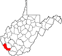 | |
| Towns | ||
| CDPs | ||
| Other communities |
| |
| Footnotes | ‡This populated place also has portions in an adjacent county or counties | |