Lyman, South Carolina
| Lyman, South Carolina Groce's Stop (until 1927) | |
|---|---|
| Town | |
 Location of Lyman, South Carolina | |
| Coordinates: 34°57′23″N 82°7′28″W / 34.95639°N 82.12444°WCoordinates: 34°57′23″N 82°7′28″W / 34.95639°N 82.12444°W | |
| Country | United States |
| State | South Carolina |
| County | Spartanburg |
| Incorporated | 1954 |
| Founded by | Augustus B. Groce |
| Named for | Arthur T. Lyman |
| Area | |
| • Total | 4.1 sq mi (10.6 km2) |
| • Land | 4.1 sq mi (10.5 km2) |
| • Water | 0.0 sq mi (0.0 km2) |
| Elevation | 886 ft (270 m) |
| Population (2010) | |
| • Total | 3,243 |
| • Density | 790/sq mi (310/km2) |
| Time zone | Eastern (EST) (UTC-5) |
| • Summer (DST) | EDT (UTC-4) |
| ZIP code | 29365 |
| Area code(s) | 864 |
| FIPS code | 45-43315[1] |
| GNIS feature ID | 1246490[2] |
| Website | www.lymansc.gov |
Lyman is a town in Spartanburg County, South Carolina, United States. It is a suburb of Greer. The population of Lyman was 3,243 at the 2010 census.[3]
History
The town of Lyman originally grew around a general store owned by Augustus Belton Groce,[4] which opened in the mid-1870s.[5] This led to the community become known as Groce's Stop.[5][6] In 1923, the Groce family sold over 700 acres (280 ha) to Pacific Mills; by the following year the Lyman Printing and Finishing Mill had been constructed, and by 1927, Pacific Mills had build 375 homes as housing for their employees.[5] The town was then renamed in memory of Arthur T. Lyman, a former president of the mill.[5][6] Lyman prospered for years as a textile town, but by 2005 the last mill was closed.[4]
McMakin's Tavern was listed on the National Register of Historic Places in 1974.[7]
Geography
Lyman is located at 34°57′23″N 82°7′28″W / 34.95639°N 82.12444°W (34.956343, -82.124559).[8]
According to the United States Census Bureau, the town has a total area of 4.1 square miles (11 km2), of which 0.25% is water.
Demographics
| Historical population | |||
|---|---|---|---|
| Census | Pop. | %± | |
| 1960 | 1,261 | — | |
| 1970 | 1,159 | −8.1% | |
| 1980 | 1,067 | −7.9% | |
| 1990 | 2,271 | 112.8% | |
| 2000 | 2,659 | 17.1% | |
| 2010 | 3,243 | 22.0% | |
| Est. 2015 | 3,423 | [9] | 5.6% |
As of the census[1] of 2000, there were 2,659 people, 1,137 households, and 770 families residing in the town. The population density was 654.0 people per square mile (252.2/km²). There were 1,224 housing units at an average density of 301.1 per square mile (116.1/km²). The racial makeup of the town was 91.69% White, 6.09% African American, 0.26% Asian, 0.11% Native American, 0.90% from other races, and 0.94% from two or more races. Hispanic or Latino of any race were 1.47% of the population.
There were 1,137 households out of which 27.5% had children under the age of 18 living with them, 54.2% were married couples living together, 10.7% had a female householder with no husband present, and 32.2% were non-families. 28.2% of all households were made up of individuals and 14.2% had someone living alone who was 65 years of age or older. The average household size was 2.32 and the average family size was 2.84.
In the town the population was spread out with 21.4% under the age of 18, 8.1% from 18 to 24, 29.8% from 25 to 44, 23.4% from 45 to 64, and 17.2% who were 65 years of age or older. The median age was 38 years. For every 100 females there were 90.6 males. For every 100 females age 18 and over, there were 84.9 males.
The median income for a household in the town was $38,750, and the median income for a family was $47,900. Males had a median income of $31,500 versus $22,950 for females. The per capita income for the town was $19,431. About 4.7% of families and 7.2% of the population were below the poverty line, including 10.9% of those under age 18 and 11.8% of those age 65 or over.
References
- 1 2 "American FactFinder". United States Census Bureau. Retrieved 2008-01-31.
- ↑ "US Board on Geographic Names". United States Geological Survey. 2007-10-25. Retrieved 2008-01-31.
- ↑ "Race, Hispanic or Latino, Age, and Housing Occupancy: 2010 Census Redistricting Data (Public Law 94-171) Summary File (QT-PL), Lyman town, South Carolina". U.S. Census Bureau, American FactFinder 2. Retrieved August 16, 2011.
- 1 2 Communities from the Spartanburg Convention & Visitors Bureau (as of 2011-08-25)
- 1 2 3 4 History and Heritage from the Lyman official website (as of 2011-08-25)
- 1 2 Lyman, South Carolina from SCIWAY.net (as of 2011-08-25)
- ↑ National Park Service (2010-07-09). "National Register Information System". National Register of Historic Places. National Park Service.
- ↑ "US Gazetteer files: 2010, 2000, and 1990". United States Census Bureau. 2011-02-12. Retrieved 2011-04-23.
- ↑ "Annual Estimates of the Resident Population for Incorporated Places: April 1, 2010 to July 1, 2015". Retrieved July 2, 2016.
- ↑ "Census of Population and Housing". Census.gov. Retrieved June 4, 2015.
External links
Municipalities and communities of Spartanburg County, South Carolina, United States | ||
|---|---|---|
| Cities | 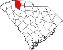 | |
| Towns | ||
| CDPs | ||
| Unincorporated communities | ||
| Ghost town | ||
| Footnotes | ‡This populated place also has portions in an adjacent county or counties | |