Marshall County, Minnesota
| Marshall County, Minnesota | |
|---|---|
 Location in the U.S. state of Minnesota | |
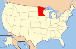 Minnesota's location in the U.S. | |
| Founded | February 25, 1879[1] |
| Named for | William Rainey Marshall, 5th Governor of Minnesota[2] |
| Seat | Warren |
| Largest city | Warren |
| Area | |
| • Total | 1,813 sq mi (4,696 km2) |
| • Land | 1,775 sq mi (4,597 km2) |
| • Water | 38 sq mi (98 km2), 2.1% |
| Population (est.) | |
| • (2015) | 9,423 |
| • Density | 5.3/sq mi (2/km²) |
| Congressional district | 7th |
| Time zone | Central: UTC-6/-5 |
| Website |
www |
Marshall County is a county located in the U.S. state of Minnesota. As of the 2010 census, the population was 9,439.[3] Its county seat is Warren.[4]
Marshall County was the location of a claimed UFO incident in 1979, the Val Johnson incident.
Geography
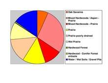
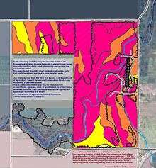
According to the U.S. Census Bureau, the county has a total area of 1,813 square miles (4,700 km2), of which 1,775 square miles (4,600 km2) is land and 38 square miles (98 km2) (2.1%) is water.[5] Marshall is one of 17 Minnesota savanna region counties where savanna soils dominate.
Major highways
Adjacent counties
- Kittson County (north)
- Roseau County (north)
- Beltrami County (east)
- Pennington County (south)
- Polk County (south)
- Grand Forks County, North Dakota (southwest)
- Walsh County, North Dakota (west)
- Pembina County, North Dakota (northwest)
Demographics
| Historical population | |||
|---|---|---|---|
| Census | Pop. | %± | |
| 1880 | 992 | — | |
| 1890 | 9,130 | 820.4% | |
| 1900 | 15,698 | 71.9% | |
| 1910 | 16,338 | 4.1% | |
| 1920 | 19,443 | 19.0% | |
| 1930 | 17,003 | −12.5% | |
| 1940 | 18,364 | 8.0% | |
| 1950 | 16,125 | −12.2% | |
| 1960 | 14,262 | −11.6% | |
| 1970 | 13,060 | −8.4% | |
| 1980 | 13,027 | −0.3% | |
| 1990 | 10,993 | −15.6% | |
| 2000 | 10,155 | −7.6% | |
| 2010 | 9,439 | −7.1% | |
| Est. 2015 | 9,423 | [7] | −0.2% |
| U.S. Decennial Census[8] 1790-1960[9] 1900-1990[10] 1990-2000[11] 2010-2015[3] | |||
As of the census of 2000, there were 10,155 people, 4,101 households and 2,837 families residing in the county. The population density was 6 per square mile (2/km²). There were 4,791 housing units at an average density of 3 per square mile (1/km²). The racial makeup of the county was 97.22% White, 0.10% Black or African American, 0.29% Native American, 0.17% Asian, 1.62% from other races, and 0.60% from two or more races. 2.93% of the population were Hispanic or Latino of any race. 43.2% were of Norwegian, 12.1% Polish, 11.7% German and 9.6% Swedish ancestry.
There were 4,101 households of which 30.20% had children under the age of 18 living with them, 60.20% were married couples living together, 5.40% had a female householder with no husband present, and 30.80% were non-families. 28.70% of all households were made up of individuals and 15.10% had someone living alone who was 65 years of age or older. The average household size was 2.45 and the average family size was 3.01.
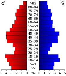
Age distribution was 25.40% under the age of 18, 6.70% from 18 to 24, 24.70% from 25 to 44, 24.70% from 45 to 64, and 18.50% who were 65 years of age or older. The median age was 40 years. For every 100 females there were 103.20 males. For every 100 females age 18 and over, there were 102.10 males.
The median household income was $34,804, and the median family income was $41,908. Males had a median income of $30,051 versus $20,600 for females. The per capita income for the county was $16,317. About 6.90% of families and 9.80% of the population were below the poverty line, including 11.30% of those under age 18 and 12.80% of those age 65 or over.
Communities
Cities
Townships
- Agder Township
- Alma Township
- Augsburg Township
- Big Woods Township
- Bloomer Township
- Boxville Township
- Cedar Township
- Como Township
- Comstock Township
- Donnelly Township
- Eagle Point Township
- East Park Township
- East Valley Township
- Eckvoll Township
- Espelie Township
- Excel Township
- Foldahl Township
- Fork Township
- Grand Plain Township
- Holt Township
- Huntly Township
- Lincoln Township
- Linsell Township
- Marsh Grove Township
- McCrea Township
- Middle River Township
- Moose River Township
- Moylan Township
- Nelson Park Township
- New Folden Township
- New Maine Township
- New Solum Township
- Oak Park Township
- Parker Township
- Rollis Township
- Sinnott Township
- Spruce Valley Township
- Tamarac Township
- Thief Lake Township
- Valley Township
- Vega Township
- Veldt Township
- Viking Township
- Wanger Township
- Warrenton Township
- West Valley Township
- Whiteford Township
- Wright Township
Unincorporated community
Unorganized territory
Ghost town
See also
- National Register of Historic Places listings in Marshall County, Minnesota
- Agassiz National Wildlife Refuge
References
- ↑ "Minnesota Place Names". Minnesota Historical Society. Retrieved March 18, 2014.
- ↑ Upham, Warren (1920). Minnesota Geographic Names: Their Origin and Historic Significance. Minnesota Historical Society. p. 326.
- 1 2 "State & County QuickFacts". United States Census Bureau. Retrieved September 1, 2013.
- ↑ "Find a County". National Association of Counties. Retrieved 2011-06-07.
- ↑ "2010 Census Gazetteer Files". United States Census Bureau. August 22, 2012. Retrieved October 21, 2014.
- ↑ Nelson, Steven (2011). Savanna Soils of Minnesota. Minnesota: Self. pp. 57 – 60. ISBN 978-0-615-50320-2.
- ↑ "County Totals Dataset: Population, Population Change and Estimated Components of Population Change: April 1, 2010 to July 1, 2015". Retrieved July 2, 2016.
- ↑ "U.S. Decennial Census". United States Census Bureau. Retrieved October 21, 2014.
- ↑ "Historical Census Browser". University of Virginia Library. Retrieved October 21, 2014.
- ↑ "Population of Counties by Decennial Census: 1900 to 1990". United States Census Bureau. Retrieved October 21, 2014.
- ↑ "Census 2000 PHC-T-4. Ranking Tables for Counties: 1990 and 2000" (PDF). United States Census Bureau. Retrieved October 21, 2014.
 |
Pembina County, North Dakota | Kittson County and Roseau County | | |
| Walsh County, North Dakota | |
Beltrami County | ||
| ||||
| | ||||
| Grand Forks County, North Dakota | Pennington County and Polk County |
Municipalities and communities of Marshall County, Minnesota, United States | ||
|---|---|---|
| Cities | | |
| Townships |
| |
| Unincorporated community | ||
| Unorganized territory | ||
| Ghost town | ||
| Indian reservation | ||
| Footnotes | ‡This populated place also has portions in an adjacent county or counties | |
Coordinates: 48°21′N 96°23′W / 48.35°N 96.38°W