Roseau County, Minnesota
| Roseau County, Minnesota | |
|---|---|
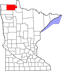 Location in the U.S. state of Minnesota | |
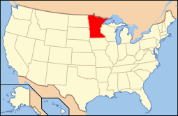 Minnesota's location in the U.S. | |
| Founded | December 31, 1894[1] |
| Named for | Roseau Lake and Roseau River[2] |
| Seat | Roseau |
| Largest city | Roseau |
| Area | |
| • Total | 1,678 sq mi (4,346 km2) |
| • Land | 1,672 sq mi (4,330 km2) |
| • Water | 6.5 sq mi (17 km2), 0.4% |
| Population (est.) | |
| • (2015) | 15,770 |
| • Density | 9.3/sq mi (4/km²) |
| Congressional district | 7th |
| Time zone | Central: UTC-6/-5 |
| Website |
www |
Roseau County is a county located in the U.S. state of Minnesota, along the Canada–US border. As of the 2010 census, the population was 15,629.[3] Its county seat is Roseau.[4] It is south from the border with Manitoba.
History
Roseau County was once the home of many Chippewa, Sioux, and Mandan tribes. Archeologists have found artifacts within the county belonging to these tribes that date back 7,200 years ago.[5]
Geography
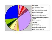
According to the U.S. Census Bureau, the county has a total area of 1,678 square miles (4,350 km2), of which 1,672 square miles (4,330 km2) is land and 6.5 square miles (17 km2) (0.4%) is water.[6] Roseau is one of 17 Minnesota savanna counties with more savanna soils than either prairie or forest soils.
Adjacent counties and rural municipalities
- Rural Municipality of Stuartburn Manitoba (northwest)
- Rural Municipality of Piney Manitoba (north)
- Lake of the Woods County (east)
- Beltrami County (southeast)
- Marshall County (south)
- Kittson County (west)
Demographics
| Historical population | |||
|---|---|---|---|
| Census | Pop. | %± | |
| 1900 | 6,994 | — | |
| 1910 | 11,338 | 62.1% | |
| 1920 | 13,305 | 17.3% | |
| 1930 | 12,621 | −5.1% | |
| 1940 | 15,103 | 19.7% | |
| 1950 | 14,505 | −4.0% | |
| 1960 | 12,154 | −16.2% | |
| 1970 | 11,569 | −4.8% | |
| 1980 | 12,574 | 8.7% | |
| 1990 | 15,026 | 19.5% | |
| 2000 | 16,338 | 8.7% | |
| 2010 | 15,629 | −4.3% | |
| Est. 2015 | 15,770 | [8] | 0.9% |
| U.S. Decennial Census[9] 1790-1960[10] 1900-1990[11] 1990-2000[12] 2010-2015[3] | |||
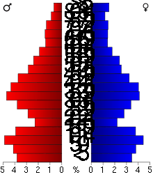
As of the census of 2000,[13] there were 16,338 people, 6,190 households, and 4,438 families residing in the county. The population density was 10 people per square mile (4/km²). There were 7,101 housing units at an average density of 4 per square mile (2/km²). The racial makeup of the county was 95.92% White, 0.13% Black or African American, 1.42% Native American, 1.73% Asian, 0.02% Pacific Islander, 0.08% from other races, and 0.70% from two or more races. 0.43% of the population were Hispanic or Latino of any race. 41.0% were of Norwegian, 18.8% German and 10.7% Swedish ancestry.
There were 6,190 households out of which 38.40% had children under the age of 18 living with them, 60.00% were married couples living together, 6.80% had a female householder with no husband present, and 28.30% were non-families. 24.60% of all households were made up of individuals and 9.90% had someone living alone who was 65 years of age or older. The average household size was 2.60 and the average family size was 3.11.
In the county the population was spread out with 29.80% under the age of 18, 6.80% from 18 to 24, 29.90% from 25 to 44, 20.80% from 45 to 64, and 12.60% who were 65 years of age or older. The median age was 35 years. For every 100 females there were 105.00 males. For every 100 females age 18 and over, there were 104.00 males.
The median income for a household in the county was $39,852, and the median income for a family was $46,185. Males had a median income of $29,747 versus $23,630 for females. The per capita income for the county was $17,053. About 4.60% of families and 6.60% of the population were below the poverty line, including 6.50% of those under age 18 and 12.20% of those age 65 or over.
Transportation
Major highways
 Minnesota State Highway 11
 Minnesota State Highway 32
 Minnesota State Highway 89
 Minnesota State Highway 308
 Minnesota State Highway 310
 Minnesota State Highway 313
Airports
Warroad International Memorial Airport (KRRT) serves the county. Piney Pinecreek Border Airport also serves the area and its location partially extends into Canada.
Politics
| Election results from statewide races[14] | ||||
|---|---|---|---|---|
| Year | Office | GOP | DEM | Others |
| 2016 | President | 69.8% | 23.8% | 6.3% |
| 2014 | Governor | 58.4% | 35.8% | 5.8% |
| Senator | 56.3% | 38.5% | 5.2% | |
| 2012 | President | 60.0% | 37.7% | 2.3% |
| Senator | 39.5% | 55.8% | 4.7% | |
| 2010 | Governor | 49.5% | 39.6% | 10.8% |
| 2008 | President | 57.6% | 40.2% | 2.2% |
| Senator | 57.5% | 31.7% | 10.8% | |
| 2006 | Governor | 56.2% | 38.8% | 5.0% |
| Senator | 46.7% | 49.4% | 3.9% | |
| 2004 | President | 67.7% | 30.9% | 1.4% |
| 2002 | Governor | 49.7% | 42.5% | 7.8% |
| Senator | 55.7% | 40.8% | 3.5% | |
| 2000 | President | 65.5% | 29.7% | 4.8% |
| Senator | 43.3% | 48.8% | 7.9% | |
| 1998 | Governor | 49.8% | 31.2% | 19.0% |
| 1996 | President | 43.2% | 39.9% | 16.9% |
| Senator | 54.6% | 40.9% | 4.5% | |
| 1994 | Governor | 59.8% | 37.6% | 2.6% |
| Senator | 59.1% | 36.6% | 4.3% | |
| 1992 | President | 38.3% | 32.2% | 29.5% |
| 1988 | President | 56.5% | 42.5% | 1.0% |
| 1984 | President | 59.3% | 39.9% | 0.8% |
| 1980 | President | 53.2% | 41.4% | 5.4% |
| 1976 | President | 41.4% | 55.9% | 2.7% |
When it comes to presidential elections, this county is the most reliable Republican county in the state. Here was John McCain's and George W. Bush's best performances in the state. Bush won here with over 65% of the vote twice. This was also one of the few counties in the state that George H. W. Bush won in 1992 and Bob Dole in 1996.
The county is less reliable for the Republican Party at the senatorial and gubernatorial levels. The Democratic-Farmer-Labor Party has won two senatorial elections here since 1992; independents do not perform here as well as the rest of the state. In 1998, Norm Coleman's best performance in the state was here where he won with almost 50% of the vote.
Communities
Cities
- Badger
- Greenbush
- Roosevelt (partly in Lake of the Woods County)
- Roseau (county seat)
- Strathcona
- Warroad
Townships
- Barnett Township
- Barto Township
- Beaver Township
- Cedarbend Township
- Deer Township
- Dewey Township
- Dieter Township
- Enstrom Township
- Falun Township
- Golden Valley Township
- Grimstad Township
- Hereim Township
- Huss Township
- Jadis Township
- Lake Township
- Laona Township
- Lind Township
- Malung Township
- Mickinock Township
- Moose Township
- Moranville Township
- Nereson Township
- Palmville Township
- Pohlitz Township
- Polonia Township
- Poplar Grove Township
- Reine Township
- Ross Township
- Skagen Township
- Soler Township
- Spruce Township
- Stafford Township
- Stokes Township
Unorganized territories
Unincorporated communities
Ghost town
See also
References
- ↑ "Minnesota Place Names". Minnesota Historical Society. Retrieved March 19, 2014.
- ↑ Upham, Warren (1920). Minnesota Geographic Names: Their Origin and Historic Significance. Minnesota Historical Society. p. 470.
- 1 2 "State & County QuickFacts". United States Census Bureau. Retrieved September 1, 2013.
- ↑ "Find a County". National Association of Counties. Retrieved 2011-06-07.
- ↑ Roseau History, Roseau, Minnesota. Accessed 2008-05-17.
- ↑ "2010 Census Gazetteer Files". United States Census Bureau. August 22, 2012. Retrieved October 24, 2014.
- ↑ Nelson, Steven (2011). Savanna Soils of Minnesota. Minnesota: Self. pp. 57-60. ISBN 978-0-615-50320-2.
- ↑ "County Totals Dataset: Population, Population Change and Estimated Components of Population Change: April 1, 2010 to July 1, 2015". Retrieved July 2, 2016.
- ↑ "U.S. Decennial Census". United States Census Bureau. Retrieved October 24, 2014.
- ↑ "Historical Census Browser". University of Virginia Library. Retrieved October 24, 2014.
- ↑ "Population of Counties by Decennial Census: 1900 to 1990". United States Census Bureau. Retrieved October 24, 2014.
- ↑ "Census 2000 PHC-T-4. Ranking Tables for Counties: 1990 and 2000" (PDF). United States Census Bureau. Retrieved October 24, 2014.
- ↑ "American FactFinder". United States Census Bureau. Retrieved 2008-01-31.
- ↑ Dave Leip's Atlas of U.S. Presidential Elections
External links
 |
Stuartburn, Manitoba, Canada | Piney, Manitoba, Canada | Division No. 1, Manitoba, Canada and Buffalo Point, Manitoba, Canada | |
| Kittson County | |
Lake of the Woods County | ||
| ||||
| | ||||
| Marshall County | Beltrami County |
Municipalities and communities of Roseau County, Minnesota, United States | ||
|---|---|---|
| Cities | | |
| Townships | ||
| Unorganized territories | ||
| Unincorporated communities | ||
| Ghost town | ||
| Indian reservation | ||
| Footnotes | ‡This populated place also has portions in an adjacent county or counties | |
Coordinates: 48°46′N 95°48′W / 48.77°N 95.80°W