Mayville, New York
| Mayville, New York | |
|---|---|
| Village | |
|
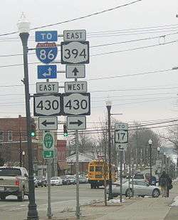
Near the intersection of Routes 430 and 394 | |
 Mayville Location within the state of New York | |
| Coordinates: 42°15′5″N 79°30′0″W / 42.25139°N 79.50000°WCoordinates: 42°15′5″N 79°30′0″W / 42.25139°N 79.50000°W | |
| Country | United States |
| State | New York |
| County | Chautauqua |
| Town | Chautauqua |
| Area | |
| • Total | 2.0 sq mi (5.2 km2) |
| • Land | 2.0 sq mi (5.2 km2) |
| • Water | 0.0 sq mi (0.0 km2) |
| Elevation | 1,453 ft (443 m) |
| Population (2010) | |
| • Total | 1,711 |
| • Density | 859/sq mi (331.8/km2) |
| Time zone | Eastern (EST) (UTC-5) |
| • Summer (DST) | EDT (UTC-4) |
| ZIP code | 14757 |
| Area code(s) | 716 |
| FIPS code | 36-46239 |
| GNIS feature ID | 0956714 |
| Website |
villageofmayville |
Mayville is a village in Chautauqua County, New York, United States. The population was 1,709 at the 2010 census,[1] which is down 2.7% from the 2000 census. The Mayville is in the town of Chautauqua and is the county seat of Chautauqua County.[2] The village and town offices share a building on Main Street, directly across from the Chautauqua County courthouse.
History
The first settlement in the county was at this location in 1804, and the village of Mayville was incorporated in 1830. In 1836 local residents rioted against the Holland Land Company and broke into its office, destroying furniture and papers.
The Pennsylvania Railroad built a train station and pier on the shores of Chautauqua Lake at Mayville. This location, along with the Jamestown boat landing at the south end of the lake, was the main mode of transportation to the rest of the communities around Chautauqua Lake via the large fleet of steamboats[3] operating before the trolley line was constructed. In modern times the steamboat Chautauqua Belle still operates out of Mayville, running between Point Chautauqua, Chautauqua Institution, and the vessel's home port in Mayville.
The Pennsylvania Railroad Station was listed on the National Register of Historic Places in 1993.[4] The Point Chautauqua Historic District was listed in 1996.[4]
Geography
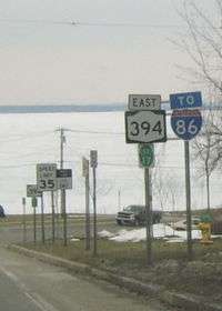
Mayville is located near the geographic center of the town of Chautauqua at 42°15′5″N 79°30′0″W / 42.25139°N 79.50000°W (42.251402, -79.500015).[5] It is situated at the northwest end of Chautauqua Lake.
Mayville is at the junction of New York State Routes 394 and 430, 7 miles (11 km) south of the New York State Thruway (Interstate 90) at Westfield.
Mayville is the nearest village to the Chautauqua Institution, which draws thousands of visitors during the summer months. Businesses in the village do a brisk tourist business both with Chautauquans and with visitors to cottages and resorts on the east and west sides of the lake.
According to the United States Census Bureau, the village has a total area of 1.99 square miles (5.16 km2), all of it land.[1]
Climate
| Climate data for Mayville, NY | |||||||||||||
|---|---|---|---|---|---|---|---|---|---|---|---|---|---|
| Month | Jan | Feb | Mar | Apr | May | Jun | Jul | Aug | Sep | Oct | Nov | Dec | Year |
| Average high °F (°C) | 34 (1) |
36 (2) |
46 (8) |
57 (14) |
69 (21) |
78 (26) |
82 (28) |
79 (26) |
72 (22) |
61 (16) |
49 (9) |
39 (4) |
58.5 (14.8) |
| Average low °F (°C) | 19 (−7) |
19 (−7) |
27 (−3) |
37 (3) |
49 (9) |
58 (14) |
63 (17) |
62 (17) |
55 (13) |
45 (7) |
35 (2) |
25 (−4) |
41.2 (5.1) |
| Average precipitation inches (mm) | 2.46 (62.5) |
2.40 (61) |
2.98 (75.7) |
3.39 (86.1) |
3.65 (92.7) |
4.37 (111) |
4.15 (105.4) |
4.45 (113) |
5.30 (134.6) |
4.75 (120.7) |
4.42 (112.3) |
3.51 (89.2) |
45.83 (1,164.2) |
| Source: The Weather Channel[6] | |||||||||||||
Demographics
| Historical population | |||
|---|---|---|---|
| Census | Pop. | %± | |
| 1870 | 701 | — | |
| 1880 | 1,051 | 49.9% | |
| 1890 | 1,164 | 10.8% | |
| 1900 | 943 | −19.0% | |
| 1910 | 1,122 | 19.0% | |
| 1920 | 1,207 | 7.6% | |
| 1930 | 1,273 | 5.5% | |
| 1940 | 1,354 | 6.4% | |
| 1950 | 1,492 | 10.2% | |
| 1960 | 1,619 | 8.5% | |
| 1970 | 1,567 | −3.2% | |
| 1980 | 1,626 | 3.8% | |
| 1990 | 1,636 | 0.6% | |
| 2000 | 1,756 | 7.3% | |
| 2010 | 1,711 | −2.6% | |
| Est. 2015 | 1,669 | [7] | −2.5% |
As of the census[9] of 2000, there were 1,756 people, 686 households, and 399 families residing in the village. The population density was 875.0 people per square mile (337.3/km²). There were 860 housing units at an average density of 428.5 per square mile (165.2/km²). The racial makeup of the village was 93.85% White, 3.64% African American, 0.51% Native American, 0.51% Asian, 0.17% from other races, and 1.31% from two or more races. Hispanic or Latino of any race were 1.59% of the population.
There were 686 households out of which 27.0% had children under the age of 18 living with them, 44.9% were married couples living together, 9.5% had a female householder with no husband present, and 41.8% were non-families. 36.6% of all households were made up of individuals and 16.8% had someone living alone who was 65 years of age or older. The average household size was 2.22 and the average family size was 2.92.
In the village the population was spread out with 21.8% under the age of 18, 10.1% from 18 to 24, 29.8% from 25 to 44, 22.2% from 45 to 64, and 16.1% who were 65 years of age or older. The median age was 38 years. For every 100 females there were 114.4 males. For every 100 females age 18 and over, there were 118.3 males.
The median income for a household in the village was $32,250, and the median income for a family was $45,595. Males had a median income of $30,574 versus $24,028 for females. The per capita income for the village was $16,561. About 5.5% of families and 10.2% of the population were below the poverty line, including 10.5% of those under age 18 and 8.4% of those age 65 or over.
Notable people
- Carlton Brandaga Curtis, former US congressman from Pennsylvania
- Michael H. Hall, Wisconsin state assemblyman
- Donald Mackenzie, explorer, fur trader and former governor of the Red River Colony
- Thomas Rodman Merritt, Upper Canada political figure
- Vin Moore, film director
- Lorenzo Morris, former New York state senator
- Victor M. Rice, former New York State Superintendent of Public Instruction and New York state assemblyman
- Albion W. Tourgée, lawyer, author, and editor; represented Homer Plessy in the infamous Plessy v. Ferguson (1896) case
- Samuel S. Whallon, former New York state assemblyman, Canal Commissioner
References
- 1 2 "Geographic Identifiers: 2010 Demographic Profile Data (G001): Mayville village, New York". U.S. Census Bureau, American Factfinder. Retrieved November 10, 2014.
- ↑ "Find a County". National Association of Counties. Archived from the original on May 31, 2011. Retrieved 2011-06-07.
- ↑ http://jamestowntrolley.org/steamer/larges/lsteamb.html
- 1 2 National Park Service (2009-03-13). "National Register Information System". National Register of Historic Places. National Park Service.
- ↑ "US Gazetteer files: 2010, 2000, and 1990". United States Census Bureau. 2011-02-12. Retrieved 2011-04-23.
- ↑ "Monthly Averages for Mayville, NY". Weather.com. 2010. Retrieved 2010-11-18.
- ↑ "Annual Estimates of the Resident Population for Incorporated Places: April 1, 2010 to July 1, 2015". Retrieved July 2, 2016.
- ↑ "Census of Population and Housing". Census.gov. Archived from the original on May 11, 2015. Retrieved June 4, 2015.
- ↑ "American FactFinder". United States Census Bureau. Archived from the original on September 11, 2013. Retrieved 2008-01-31.
External links
Municipalities and communities of Chautauqua County, New York, United States | ||
|---|---|---|
| Cities | 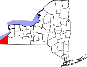 | |
| Towns | ||
| Villages | ||
| CDPs | ||
| Other hamlets | ||
| Indian reservation | ||