McDade, Alabama
| McDade, Alabama | |
|---|---|
| Unincorporated community | |
 McDade, Alabama  McDade, Alabama | |
| Coordinates: 32°18′57″N 86°02′47″W / 32.31583°N 86.04639°WCoordinates: 32°18′57″N 86°02′47″W / 32.31583°N 86.04639°W | |
| Country | United States |
| State | Alabama |
| County | Montgomery |
| Elevation | 249 ft (76 m) |
| Time zone | Central (CST) (UTC-6) |
| • Summer (DST) | CDT (UTC-5) |
| Area code(s) | 334 |
| GNIS feature ID | 156683[1] |
McDade is an unincorporated community in Montgomery County, Alabama, United States. McDade is located near the intersection of Alabama State Route 293 and Alabama State Route 110, 16.9 miles (27.2 km) east of Montgomery. The community was settled in the 1820s and named for a prominent local family.[2]
References
- ↑ "McDade". Geographic Names Information System. United States Geological Survey.
- ↑ Foscue, Virginia (1989). Place Names in Alabama. Tuscaloosa: The University of Alabama Press. p. 88. ISBN 0-8173-0410-X.
Municipalities and communities of Montgomery County, Alabama, United States | ||
|---|---|---|
| Cities | 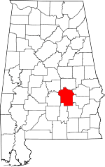 | |
| Towns | ||
| Unincorporated communities | ||
| Footnotes | ‡This populated place also has portions in an adjacent county or counties | |
This article is issued from Wikipedia - version of the 7/31/2016. The text is available under the Creative Commons Attribution/Share Alike but additional terms may apply for the media files.