Mexia, Alabama
| Mexia, Alabama | |
|---|---|
| Unincorporated community | |
 Mexia, Alabama  Mexia, Alabama | |
| Coordinates: 31°30′26″N 87°23′18″W / 31.50722°N 87.38833°WCoordinates: 31°30′26″N 87°23′18″W / 31.50722°N 87.38833°W | |
| Country | United States |
| State | Alabama |
| County | Monroe |
| Elevation | 413 ft (126 m) |
| Time zone | Central (CST) (UTC-6) |
| • Summer (DST) | CDT (UTC-5) |
| ZIP code | 36458 |
| Area code(s) | 251 |
| GNIS feature ID | 122677[1] |
Mexia is an unincorporated community in Monroe County, Alabama, United States. Mexia is located on Alabama State Route 47, 4 miles (6.4 km) west-southwest of Monroeville. Mexia has a post office with ZIP code 36458.[2][3] Mexia has two small historic cemeteries on Thompson Road and Rolland Road. The largest church in Mexia is Mexia Baptist Church located on Old Salem Road.[4] In Mexia there is also New Chapel Baptist Church located on Snowden Road, and Old Salem Baptist Church located on Old Salem Creek Road.[5]
References
- ↑ "Mexia". Geographic Names Information System. United States Geological Survey.
- ↑ United States Postal Service (2012). "USPS - Look Up a ZIP Code". Retrieved 2012-02-15.
- ↑ "Postmaster Finder - Post Offices by ZIP Code". United States Postal Service. Retrieved December 21, 2012.
- ↑ Residency in Mexia AL
- ↑ Residency in Mexia AL
Municipalities and communities of Monroe County, Alabama, United States | ||
|---|---|---|
| City | 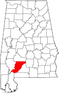 | |
| Towns | ||
| CDPs | ||
| Unincorporated communities | ||
| Ghost town | ||
This article is issued from Wikipedia - version of the 9/21/2016. The text is available under the Creative Commons Attribution/Share Alike but additional terms may apply for the media files.