Mošenik, Zagorje ob Savi
| Mošenik | |
|---|---|
|
Mošenik during the 2009 floods in Slovenia | |
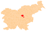
 Mošenik Location in Slovenia | |
| Coordinates: 46°5′53.32″N 14°55′12.76″E / 46.0981444°N 14.9202111°ECoordinates: 46°5′53.32″N 14°55′12.76″E / 46.0981444°N 14.9202111°E | |
| Country |
|
| Traditional region | Upper Carniola |
| Statistical region | Central Sava |
| Municipality | Zagorje ob Savi |
| Area | |
| • Total | 1.92 km2 (0.74 sq mi) |
| Elevation | 289.1 m (948.5 ft) |
| Population (2002) | |
| • Total | 41 |
| [1] | |
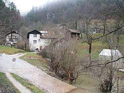
Mošenik (pronounced [mɔʃɛˈniːk]) is a settlement on the left bank of the Sava River in the Municipality of Zagorje ob Savi in central Slovenia. The railway line from Ljubljana to Zidani Most runs through the settlement. The area is part of the traditional region of Upper Carniola. It is now included with the rest of the municipality in the Central Sava Statistical Region.[2]
References
External links
 Media related to Mošenik, Zagorje ob Savi at Wikimedia Commons
- Mošenik on Geopedia
This article is issued from Wikipedia - version of the 3/16/2015. The text is available under the Creative Commons Attribution/Share Alike but additional terms may apply for the media files.