Monaville, West Virginia
| Monaville | |
|---|---|
| Census-designated place (CDP) | |
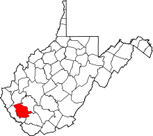
 Monaville Location within the state of West Virginia | |
| Coordinates: 37°48′43″N 81°59′41″W / 37.81194°N 81.99472°WCoordinates: 37°48′43″N 81°59′41″W / 37.81194°N 81.99472°W | |
| Country | United States |
| State | West Virginia |
| County | Logan |
| Area[1] | |
| • Total | 0.464 sq mi (1.20 km2) |
| • Land | 0.457 sq mi (1.18 km2) |
| • Water | 0.007 sq mi (0.02 km2) |
| Elevation[2] | 712 ft (217 m) |
| Population (2010)[3] | |
| • Total | 309 |
| • Density | 670/sq mi (260/km2) |
| Time zone | Eastern (EST) (UTC-5) |
| • Summer (DST) | EDT (UTC-4) |
Monaville is a census-designated place (CDP) in Logan County, West Virginia, United States.[2] As of the 2010 census, its population was 309.[3] It lies in the valley of Island Creek, a tributary of the Guyandotte River near the city of Logan. Monaville is situated between the unincorporated communities of Wilkinson and Rossmore.
History
Monaville formerly held the US Postal ZIP code 25636 until the Post Office was closed by the US Postal Service. Monaville was formerly known as "Vanceville" and was listed as such on a US Postal Service Map of the late 1890s. The region was likely named for the Vance family who owned much of the land prior to the coal mining era.
The name was believed to have been changed to Monaville in honor of Mona Wilkinson, the daughter of a prominent coal mining official. The Logan Mining Company operated a coal mine here and the name Mona Mine appears on a 1918 photo of the coal tipple.
Island Creek Coal Company, based in Holden, operated the #11 and #12 mines in this region. Monaville is the location of the Foster Armory, which houses a West Virginia National Guard unit. The state archives is currently rebuilding the original split-log Monaville schoolhouse in the basement of the state capitol complex.
References
- ↑ "US Gazetteer files: 2010, 2000, and 1990". United States Census Bureau. 2011-02-12. Retrieved 2011-04-23.
- 1 2 U.S. Geological Survey Geographic Names Information System: Monaville, West Virginia
- 1 2 "American FactFinder". United States Census Bureau. Retrieved 2011-05-14.