Morrill, Kansas
| Morrill, Kansas | |
|---|---|
| City | |
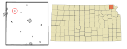 Location within Brown County and Kansas | |
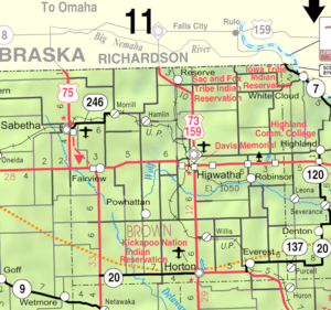 KDOT map of Brown County (legend) | |
| Coordinates: 39°55′48″N 95°41′40″W / 39.93000°N 95.69444°WCoordinates: 39°55′48″N 95°41′40″W / 39.93000°N 95.69444°W | |
| Country | United States |
| State | Kansas |
| County | Brown |
| Area[1] | |
| • Total | 0.19 sq mi (0.49 km2) |
| • Land | 0.19 sq mi (0.49 km2) |
| • Water | 0 sq mi (0 km2) |
| Elevation | 1,096 ft (334 m) |
| Population (2010)[2] | |
| • Total | 230 |
| • Estimate (2012[3]) | 228 |
| • Density | 1,200/sq mi (470/km2) |
| Time zone | Central (CST) (UTC-6) |
| • Summer (DST) | CDT (UTC-5) |
| ZIP code | 66515 |
| Area code(s) | 785 |
| FIPS code | 20-48300 [4] |
| GNIS feature ID | 0472771 [5] |
Morrill is a city in Brown County, Kansas, United States. As of the 2010 census, the city population was 230.[6]
History
Morrill was laid out in 1878 when the St. Joseph and Western Railroad was extended to that point.[7] It was named for Kansas governor Edmund Needham Morrill.[8]
Geography
Morrill is located at 39°55′48″N 95°41′40″W / 39.93000°N 95.69444°W (39.929879, -95.694498).[9] According to the United States Census Bureau, the city has a total area of 0.19 square miles (0.49 km2), all of it land.[1]
Demographics
| Historical population | |||
|---|---|---|---|
| Census | Pop. | %± | |
| 1890 | 308 | — | |
| 1900 | 400 | 29.9% | |
| 1910 | 398 | −0.5% | |
| 1920 | 552 | 38.7% | |
| 1930 | 519 | −6.0% | |
| 1940 | 387 | −25.4% | |
| 1950 | 362 | −6.5% | |
| 1960 | 299 | −17.4% | |
| 1970 | 308 | 3.0% | |
| 1980 | 336 | 9.1% | |
| 1990 | 299 | −11.0% | |
| 2000 | 277 | −7.4% | |
| 2010 | 230 | −17.0% | |
| Est. 2015 | 227 | [10] | −1.3% |
| U.S. Decennial Census | |||
2010 census
As of the census[2] of 2010, there were 230 people, 88 households, and 66 families residing in the city. The population density was 1,210.5 inhabitants per square mile (467.4/km2). There were 105 housing units at an average density of 552.6 per square mile (213.4/km2). The racial makeup of the city was 96.5% White, 1.3% Native American, and 2.2% from two or more races. Hispanic or Latino of any race were 2.2% of the population.
There were 88 households of which 36.4% had children under the age of 18 living with them, 62.5% were married couples living together, 6.8% had a female householder with no husband present, 5.7% had a male householder with no wife present, and 25.0% were non-families. 20.5% of all households were made up of individuals and 8% had someone living alone who was 65 years of age or older. The average household size was 2.61 and the average family size was 2.91.
The median age in the city was 38 years. 27% of residents were under the age of 18; 5.7% were between the ages of 18 and 24; 24.4% were from 25 to 44; 32.6% were from 45 to 64; and 10.4% were 65 years of age or older. The gender makeup of the city was 49.6% male and 50.4% female.
2000 census
As of the census[4] of 2000, there were 277 people, 101 households, and 75 families residing in the city. The population density was 1,340.2 people per square mile (509.3/km²). There were 113 housing units at an average density of 546.7 per square mile (207.8/km²). The racial makeup of the city was 96.03% White, 1.44% African American, 0.36% Pacific Islander, and 2.17% from two or more races. Hispanic or Latino of any race were 0.36% of the population.
There were 101 households out of which 35.6% had children under the age of 18 living with them, 64.4% were married couples living together, 6.9% had a female householder with no husband present, and 24.8% were non-families. 22.8% of all households were made up of individuals and 6.9% had someone living alone who was 65 years of age or older. The average household size was 2.74 and the average family size was 3.24.
In the city the population was spread out with 30.3% under the age of 18, 7.6% from 18 to 24, 28.9% from 25 to 44, 22.7% from 45 to 64, and 10.5% who were 65 years of age or older. The median age was 36 years. For every 100 females there were 95.1 males. For every 100 females age 18 and over, there were 107.5 males.
The median income for a household in the city was $30,357, and the median income for a family was $32,813. Males had a median income of $30,250 versus $17,500 for females. The per capita income for the city was $11,924. About 24.7% of families and 34.0% of the population were below the poverty line, including 56.8% of those under the age of eighteen and none of those sixty five or over.
Notable people
- Howard Shultz Miller, former U.S. Representative from Kansas.[11]
References
- 1 2 "US Gazetteer files 2010". United States Census Bureau. Retrieved 2012-07-06.
- 1 2 "American FactFinder". United States Census Bureau. Retrieved 2012-07-06.
- ↑ "Population Estimates". United States Census Bureau. Retrieved 2013-05-29.
- 1 2 "American FactFinder". United States Census Bureau. Retrieved 2008-01-31.
- ↑ "US Board on Geographic Names". United States Geological Survey. 2007-10-25. Retrieved 2008-01-31.
- ↑ "2010 City Population and Housing Occupancy Status". U.S. Census Bureau. Retrieved April 9, 2012.
- ↑ History of the State of Kansas: Containing a Full Account of Its Growth from an Uninhabited Territory to a Wealthy and Important State. A. T. Andreas. 1883. p. 740.
- ↑ Kansas Place-Names,John Rydjord, University of Oklahoma Press, 1972, p. 330 ISBN 0-8061-0994-7
- ↑ "US Gazetteer files: 2010, 2000, and 1990". United States Census Bureau. 2011-02-12. Retrieved 2011-04-23.
- ↑ "Annual Estimates of the Resident Population for Incorporated Places: April 1, 2010 to July 1, 2015". Retrieved July 2, 2016.
- ↑ "MILLER, Howard Shultz, (1879 - 1970)". Biographical Directory of the United States Congress. Retrieved October 14, 2012.
External links
| Wikimedia Commons has media related to Morrill, Kansas. |
- City
- Schools
- USD 113, local school district
- Maps
- Morrill City Map, KDOT
Municipalities and communities of Brown County, Kansas, United States | ||
|---|---|---|
| Cities | 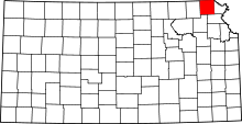 | |
| CDPs | ||
| Unincorporated communities | ||
| Indian reservations | ||
| Townships | ||
| Footnotes | ‡This populated place also has portions in an adjacent county or counties | |