Willis, Kansas
| Willis, Kansas | |
|---|---|
| City | |
 Location within Brown County and Kansas | |
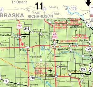 KDOT map of Brown County (legend) | |
| Coordinates: 39°43′27″N 95°30′20″W / 39.72417°N 95.50556°WCoordinates: 39°43′27″N 95°30′20″W / 39.72417°N 95.50556°W | |
| Country | United States |
| State | Kansas |
| County | Brown |
| Area[1] | |
| • Total | 0.17 sq mi (0.44 km2) |
| • Land | 0.17 sq mi (0.44 km2) |
| • Water | 0 sq mi (0 km2) |
| Elevation | 1,161 ft (354 m) |
| Population (2010)[2] | |
| • Total | 38 |
| • Estimate (2012[3]) | 38 |
| • Density | 220/sq mi (86/km2) |
| Time zone | Central (CST) (UTC-6) |
| • Summer (DST) | CDT (UTC-5) |
| ZIP code | 66434 |
| Area code(s) | 785 |
| FIPS code | 20-79400 [4] |
| GNIS feature ID | 0473248 [5] |
Willis is a city in Brown County, Kansas, United States. As of the 2010 census, the city population was 38.[6]
History
Willis had its start as a station on the Missouri Pacific Railroad.[7] A post office opened in Willis in 1882 and remained in operation until it was discontinued in 1960.[8]
Geography
Willis is located at 39°43′27″N 95°30′20″W / 39.72417°N 95.50556°W (39.724165, -95.505479).[9] According to the United States Census Bureau, the city has a total area of 0.17 square miles (0.44 km2), all of it land.[1]
Demographics
| Historical population | |||
|---|---|---|---|
| Census | Pop. | %± | |
| 1900 | 187 | — | |
| 1910 | 188 | 0.5% | |
| 1920 | 197 | 4.8% | |
| 1930 | 217 | 10.2% | |
| 1940 | 160 | −26.3% | |
| 1950 | 140 | −12.5% | |
| 1960 | 109 | −22.1% | |
| 1970 | 82 | −24.8% | |
| 1980 | 85 | 3.7% | |
| 1990 | 86 | 1.2% | |
| 2000 | 69 | −19.8% | |
| 2010 | 38 | −44.9% | |
| Est. 2015 | 37 | [10] | −2.6% |
| U.S. Decennial Census | |||
2010 census
As of the census[2] of 2010, there were 38 people, 19 households, and 13 families residing in the city. The population density was 223.5 inhabitants per square mile (86.3/km2). There were 27 housing units at an average density of 158.8 per square mile (61.3/km2). The racial makeup of the city was 92.1% White, 2.6% Native American, and 5.3% from two or more races.
There were 19 households of which 15.8% had children under the age of 18 living with them, 63.2% were married couples living together, 5.3% had a male householder with no wife present, and 31.6% were non-families. 31.6% of all households were made up of individuals and 5.3% had someone living alone who was 65 years of age or older. The average household size was 2.00 and the average family size was 2.46.
The median age in the city was 48.8 years. 13.2% of residents were under the age of 18; 7.8% were between the ages of 18 and 24; 18.4% were from 25 to 44; 36.9% were from 45 to 64; and 23.7% were 65 years of age or older. The gender makeup of the city was 47.4% male and 52.6% female.
2000 census
As of the census[4] of 2000, there were 69 people, 22 households, and 17 families residing in the city. The population density was 409.3 people per square mile (156.7/km²). There were 29 housing units at an average density of 172.0 per square mile (65.9/km²). The racial makeup of the city was 78.26% White, 5.80% African American, 13.04% Native American, and 2.90% from two or more races. Hispanic or Latino of any race were 8.70% of the population.
There were 22 households out of which 45.5% had children under the age of 18 living with them, 63.6% were married couples living together, 9.1% had a female householder with no husband present, and 18.2% were non-families. 13.6% of all households were made up of individuals and 4.5% had someone living alone who was 65 years of age or older. The average household size was 3.14 and the average family size was 3.56.
In the city the population was spread out with 34.8% under the age of 18, 10.1% from 18 to 24, 30.4% from 25 to 44, 18.8% from 45 to 64, and 5.8% who were 65 years of age or older. The median age was 32 years. For every 100 females there were 91.7 males. For every 100 females age 18 and over, there were 104.5 males.
The median income for a household in the city was $28,125, and the median income for a family was $30,000. Males had a median income of $17,188 versus $17,188 for females. The per capita income for the city was $12,592. There were no families and 4.8% of the population living below the poverty line, including no under eighteens and none of those over 64.
References
- 1 2 "US Gazetteer files 2010". United States Census Bureau. Retrieved 2012-07-06.
- 1 2 "American FactFinder". United States Census Bureau. Retrieved 2012-07-06.
- ↑ "Population Estimates". United States Census Bureau. Retrieved 2013-05-29.
- 1 2 "American FactFinder". United States Census Bureau. Retrieved 2008-01-31.
- ↑ "US Board on Geographic Names". United States Geological Survey. 2007-10-25. Retrieved 2008-01-31.
- ↑ "2010 City Population and Housing Occupancy Status". U.S. Census Bureau. Retrieved April 9, 2012.
- ↑ History of the State of Kansas: Containing a Full Account of Its Growth from an Uninhabited Territory to a Wealthy and Important State. A. T. Andreas. 1883. p. 746.
- ↑ "Kansas Post Offices, 1828-1961, page 2 (archived)". Kansas Historical Society. Archived from the original on October 9, 2013. Retrieved 4 June 2014.
- ↑ "US Gazetteer files: 2010, 2000, and 1990". United States Census Bureau. 2011-02-12. Retrieved 2011-04-23.
- ↑ "Annual Estimates of the Resident Population for Incorporated Places: April 1, 2010 to July 1, 2015". Retrieved July 2, 2016.
External links
| Wikimedia Commons has media related to Willis, Kansas. |
- City
- Schools
- USD 430, local school district
- Maps
- Willis City Map, KDOT
Municipalities and communities of Brown County, Kansas, United States | ||
|---|---|---|
| Cities | 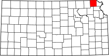 | |
| CDPs | ||
| Unincorporated communities | ||
| Indian reservations | ||
| Townships | ||
| Footnotes | ‡This populated place also has portions in an adjacent county or counties | |