Mount Airy, New Jersey
| Mount Airy, New Jersey | |
|---|---|
| Unincorporated community | |
|
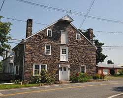
Historic storehouse in Mount Airy | |
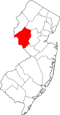
 Mount Airy, New Jersey  Mount Airy, New Jersey  Mount Airy, New Jersey Location of Mount Airy in Hunterdon County Inset: Location of county within the state of New Jersey | |
| Coordinates: 40°23′55″N 74°54′26″W / 40.39861°N 74.90722°WCoordinates: 40°23′55″N 74°54′26″W / 40.39861°N 74.90722°W | |
| Country |
|
| State |
|
| County | Hunterdon |
| Township | West Amwell |
| Elevation[1] | 259 ft (79 m) |
| GNIS feature ID | 878514[1] |
|
Mount Airy Historic District | |
| NRHP Reference # | 89001943[2] |
|---|---|
| Added to NRHP | November 13, 1989 |
Mount Airy is an unincorporated community located within West Amwell Township in Hunterdon County, New Jersey, United States.[3]
History
A mill existed on the Alexauken Creek east of Mount Airy prior to the Revolution. By 1881, Mount Airy had a school, store, church, wagon and blacksmith shop, grist-mill, and about 12 dwellings. Prior to 1881 a hotel was located at the settlement.[4]
References
- 1 2 "Mount Airy". Geographic Names Information System. United States Geological Survey.
- ↑ National Park Service (2009-03-13). "National Register Information System". National Register of Historic Places. National Park Service.
- ↑ Locality Search, State of New Jersey. Accessed January 31, 2015.
- ↑ Snell, James P. (1881). History of Hunterdon and Somerset Counties, New Jersey. Everts & Peck. pp. 346, 349.
| Topics |  | ||
|---|---|---|---|
| Lists by county | |||
| Lists by city |
| ||
| Other lists | |||
| |||
This article is issued from Wikipedia - version of the 6/9/2016. The text is available under the Creative Commons Attribution/Share Alike but additional terms may apply for the media files.