Mount Airy Historic District (Mount Airy, North Carolina)
|
Mount Airy Historic District | |
|
Mount Airy Historic District, January 2011 | |
  | |
| Location | Main, Brown, Market, Franklin, W. Pine, Rockford, Worth, Cherry, and Gilmer Sts., Moore, and Hines Aves.; Willow & W. Oak Sts., Mount Airy, North Carolina |
|---|---|
| Coordinates | 36°29′59″N 80°36′25″W / 36.49972°N 80.60694°WCoordinates: 36°29′59″N 80°36′25″W / 36.49972°N 80.60694°W |
| Area | 115 acres (47 ha) |
| Architectural style | Late 19th And 20th Century Revivals, Bungalow/craftsman, Late Victorian |
| NRHP Reference # | 85002931, 12000581 (Boundary Increase)[1] |
| Added to NRHP | October 3, 1985, August 28, 2012 (Boundary Increase) |
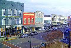
Mount Airy Historic District is a national historic district located at Mount Airy, Surry County, North Carolina. The district encompasses 187 contributing buildings in the central business district and surrounding industrial and residential sections of Mount Airy. They were primarily built between about 1880 and 1930 and include notable examples of Late Victorian and Bungalow / American Craftsman architecture. Located in the district are the separately listed W. F. Carter House and Trinity Episcopal Church. Other notable buildings include the Abram Haywood Merritt House (1902), William A. Estes House (c. 1875), Thomas Fawcett House (c. 1895), J. D. Sargent House (1919), T. Benton Ashby House (c. 1912), First Baptist Church (1906-1912), Mount Airy Friends (1904), Presbyterian Church (1907-1914), Merritt Building (c. 1905-1910), Banner Building (1906), Prather Block (c. 1892), Midkiff Hardware Store (c. 1910), Welch Block (c. 1890), West Drug Store (c. 1895), Belk's Building (c. 1890), (former) Workman's Federal Savings and Loan (c. 1891), (former) First National Bank (1893), Bank of Mount Airy (1923), U.S. Post Office (1932-1933), and the Sparger Brothers Tobacco Factory.[2][3]
It was added to the National Register of Historic Places in 1985, with a boundary increase in 2012.[1]
References
- 1 2 National Park Service (2010-07-09). "National Register Information System". National Register of Historic Places. National Park Service.
- ↑ Patricia S. Dickinson (June 1985). "Mount Airy Historic District" (pdf). National Register of Historic Places - Nomination and Inventory. North Carolina State Historic Preservation Office. Retrieved 2015-05-01.
- ↑ Laura A. W. Phillips (June 1985). "Mount Airy Historic District (Boundary Increase)" (pdf). National Register of Historic Places - Nomination and Inventory. North Carolina State Historic Preservation Office. Retrieved 2015-05-01.