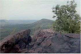
Mount Holyoke Range State Park
Mount Holyoke Range State Park is a state-owned, public recreation area managed by the Massachusetts Department of Conservation and Recreation encompassing the eastern half of the Holyoke Range in the Pioneer Valley region of Massachusetts. The state park is adjacent to J. A. Skinner State Park, which occupies the western half of the Holyoke Range.[5]
Activities and amenities
Park trails are used for hiking, horseback riding, and cross-country skiing. Trails include sections of the long-distance Metacomet-Monadnock and Robert Frost trails. A visitors center is located near "The Notch"[6] on Route 116 in Amherst. Picnicking and restricted hunting are also offered.[5]
References
External links
|
|---|
|
|
|
|
|
|
|
| Wildlife Management Areas |
|---|
| Wildlife
Management Areas | |
|---|
| Wildlife
Sanctuaries |
- Billingsgate Island
- Carr Island
- E. Howe Forbush
- Egg Rock
- Grace A. Robson
- J.C. Phillips
- Knight
- Penikese Island
- Ram Island (Salisbury)
- Ram Island (Mattapoisett)
- Susan B. Minns
- Tarpaulin Cove
- Watatic Mountain
|
|---|
|
|
|
| |
|---|
|
- Black Pond Bog
- Boat Meadow
- Francis Newhall Woods
- Grassy Pond
- Greene Swamp
- Halfway Pond Island
- Hawley Bog
- Hockomock Swamp
- Hoft Farm
- Homer-Watcha Preserve
- Katama Plains
- McElwain-Olsen
- Miacomet Moors
- Reed Brook
- Drury
- Sandy Neck
- David H. Smith Preserve and Fire Trail
- Stacy Mountain
- Tatkon
|
|
|
|
|
|
|
|
|
|