Mystic River Railroad Bridge (Connecticut)
| Mystic River Railroad Bridge | |
|---|---|
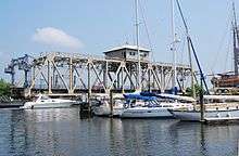 Mystic River Railroad Bridge in August 2010 | |
| Coordinates | 41°20′56″N 71°58′13″W / 41.34889°N 71.97028°WCoordinates: 41°20′56″N 71°58′13″W / 41.34889°N 71.97028°W |
| Carries | Northeast Corridor |
| Crosses | Mystic River |
| Locale | Groton and Stonington, Connecticut |
| Official name | Mystic River Bridge |
| Maintained by | Amtrak |
| Characteristics | |
| Design | Swing bridge |
| Material | Steel |
| History | |
| Opened | 1819 (First bridge), 1875 (Second bridge), 1984 (Third Bridge) |
The Mystic River Railroad Bridge is a railroad bridge carrying Amtrak's Northeast Corridor over the Mystic River in Mystic, Connecticut, between the towns of Groton and Stonington.
There have been three bridges at this location. The first bridge was a single-tracked, wooden drawbridge in 1819, which was replaced with a steel swing bridge in 1875.[1]
The current bridge was built in 1984, and is a truss-style swing bridge, providing 13 feet (4.0 m) of vertical clearance when closed.[2]
The two tracks running over the bridge are owned by Amtrak, are part of it's Northeast Corridor route, and are used to operate its Northeast Regional and Acela Express services. There is a proposal, however, to extend Shore Line East Commuter Rail Service from its current terminus in New London to Mystic, which would require crossing this bridge.
The bridge is the easternmost drawbridge on the Amtrak-owned Northeast Corridor in Connecticut.
See also
References
- ↑ Artemel, Janice G. (1983). "New York, New Haven & Hartford Railroad, Mystic River Bridge" (PDF). Historic American Engineering Record. Washington, D.C.: Library of Congress. Retrieved January 14, 2015.
- ↑ http://www.mysticseaport.org/research/
External links
| Wikimedia Commons has media related to Mystic River Railroad Bridge. |
- Historic American Engineering Record (HAER) No. CT-26, "New York, New Haven & Hartford Railroad, Mystic River Bridge, Spanning Mystic River between Groton & Stonington, Groton, New London County, CT", 14 photos, 10 data pages, 1 photo caption page