| [2] |
Name on the Register[3] |
Image |
Date listed[4] |
Location |
City or town |
Description |
|---|
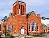
| 1 |
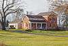
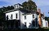
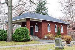
All Saints' Episcopal Church |
|
000000001984-12-27-0000December 27, 1984
(#84000511) |
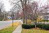
252 Grand St.
42°39′23″N 86°12′03″W / 42.656389°N 86.200833°W / 42.656389; -86.200833 (All Saints' Episcopal Church) |
Saugatuck |
|
| 2 |
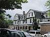
Edward D. Born House |
|
000000001987-03-12-0000March 12, 1987
(#87000237) |
158 Hill St.
42°32′03″N 85°50′40″W / 42.534167°N 85.844444°W / 42.534167; -85.844444 (Edward D. Born House) |
Allegan |
|
| 3 |
Engelbert B. Born House |
|
000000001987-03-12-0000March 12, 1987
(#87000238) |
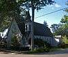
128 Hill St.
42°31′59″N 85°50′41″W / 42.533056°N 85.844722°W / 42.533056; -85.844722 (Engelbert B. Born House) |
Allegan |
|
| 4 |
William H. Brown House |
|
000000001987-07-08-0000July 8, 1987
(#87000239) |
800 Ely St.
42°31′09″N 85°51′55″W / 42.519167°N 85.865278°W / 42.519167; -85.865278 (William H. Brown House) |
Allegan |
|
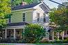
| 5 |
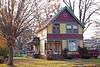
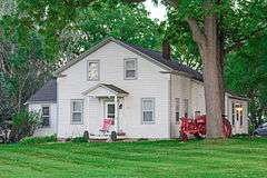
Cherry DeLefebvre House |
|
000000001991-11-01-0000November 1, 1991
(#91001548) |
115 W. Chart St.
42°26′30″N 85°38′32″W / 42.441667°N 85.642222°W / 42.441667; -85.642222 (Cherry DeLefebvre House) |
Plainwell |
|
| 6 |
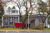
Douglas Union School |
|
000000001995-07-21-0000July 21, 1995
(#95000870) |
130 Center St.
42°38′39″N 86°12′13″W / 42.644167°N 86.203611°W / 42.644167; -86.203611 (Douglas Union School) |
Douglas |
|
| 7 |
Downtown Allegan Historic District |
Upload image |
000000001987-03-12-0000March 12, 1987
(#87000251) |
Roughly bounded by Trowbridge, Locust, Hubbard, Brady, and Water Sts.
42°31′39″N 85°50′58″W / 42.5275°N 85.849444°W / 42.5275; -85.849444 (Downtown Allegan Historic District) |
Allegan |
|
| 8 |
J. F. Eesley Milling Co. Flour Mill-Elevator |
|
000000001991-11-01-0000November 1, 1991
(#91001547) |
717 E. Bridge St.
42°26′35″N 85°37′54″W / 42.443056°N 85.631667°W / 42.443056; -85.631667 (J. F. Eesley Milling Co. Flour Mill-Elevator) |
Plainwell |
|
| 9 |
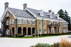
Dorr E. Felt Mansion |
|
000000001996-12-12-0000December 12, 1996
(#96001418) |
66th St., north of 138th Ave., Laketown Township
42°41′49″N 86°11′37″W / 42.696944°N 86.193611°W / 42.696944; -86.193611 (Dorr E. Felt Mansion) |
Saugatuck |
|
| 10 |
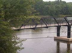
Fifty-Seventh Street Bridge |
|
000000001998-04-01-0000April 1, 1998
(#98000273) |
57th St. over the Kalamazoo River
42°39′05″N 86°06′25″W / 42.651389°N 86.106944°W / 42.651389; -86.106944 (Fifty-Seventh Street Bridge) |
Manlius Township |
|
| 11 |
Francis Metallic Surfboat |
Upload image |
000000002015-04-21-0000April 21, 2015
(#15000156) |
130 W. Center St.
42°38′39″N 86°12′12″W / 42.644153°N 86.203412°W / 42.644153; -86.203412 (Francis Metallic Surfboat) |
Douglas |
|
| 12 |
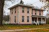
Henry Franks House |
|
000000001987-03-12-0000March 12, 1987
(#87000252) |
535 Ely St.
42°31′26″N 85°51′33″W / 42.523889°N 85.859167°W / 42.523889; -85.859167 (Henry Franks House) |
Allegan |
|
| 13 |
Griswold Civic Center Historic District |
|
000000001987-03-12-0000March 12, 1987
(#87000253) |
Roughly bounded by Hubbard, Walnut, and Trowbridge Sts.
42°31′38″N 85°51′10″W / 42.527222°N 85.852778°W / 42.527222; -85.852778 (Griswold Civic Center Historic District) |
Allegan |
|
| 14 |
Hacklander Site |
|
000000001973-07-27-0000July 27, 1973
(#73002150) |
Address Restricted
|
Douglas |
|
| 15 |
HENNEPIN Self-unloading Steamship (Shipwreck) |
|
000000002008-02-01-0000February 1, 2008
(#07001489) |
Address Restricted
|
South Haven |
|
| 16 |
Island Historic District |
Upload image |
000000001991-11-01-0000November 1, 1991
(#91001546) |
Roughly bounded by Hill St., Anderson St., the mill race, Park St., Bannister St. and the Kalamazoo River
42°26′26″N 85°38′24″W / 42.440556°N 85.64°W / 42.440556; -85.64 (Island Historic District) |
Plainwell |
|
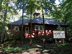
| 17 |
Lake Shore Chapel |
|
000000001997-03-28-0000March 28, 1997
(#97000280) |
Shorewood Rd., junction with Campbell Rd.
42°39′02″N 86°13′18″W / 42.650556°N 86.221667°W / 42.650556; -86.221667 (Lake Shore Chapel) |
Douglas |
|
| 18 |
Leiendecker's Inn-Coral Gables |
|
000000002009-07-16-0000July 16, 2009
(#09000520) |
220 Water St.
42°39′21″N 86°12′19″W / 42.655758°N 86.205225°W / 42.655758; -86.205225 (Leiendecker's Inn-Coral Gables) |
Saugatuck |
|
| 19 |
Augustus Lilly House |
|
000000001987-03-12-0000March 12, 1987
(#87000254) |
132 Cora St.
42°32′17″N 85°50′41″W / 42.538056°N 85.844722°W / 42.538056; -85.844722 (Augustus Lilly House) |
Allegan |
|
| 20 |
Marshall Street Historic District |
Upload image |
000000001987-03-12-0000March 12, 1987
(#87000256) |
231-237, 335-705, 232-630 Marshall St.
42°31′16″N 85°50′34″W / 42.521111°N 85.842778°W / 42.521111; -85.842778 (Marshall Street Historic District) |
Allegan |
|
| 21 |
William C. Messenger House |
|
000000001987-03-12-0000March 12, 1987
(#87000258) |
310 River St.
42°32′03″N 85°50′54″W / 42.534167°N 85.848333°W / 42.534167; -85.848333 (William C. Messenger House) |
Allegan |
|
| 22 |
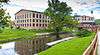
Michigan Paper Company Mill Historic District |
|
000000002011-09-08-0000September 8, 2011
(#11000636) |
200 Allegan St.
42°32′03″N 85°50′54″W / 42.534167°N 85.848333°W / 42.534167; -85.848333 (Michigan Paper Company Mill Historic District) |
Plainwell |
|
| 23 |
Navigation Structures at Saugatuck Harbor |
Upload image |
000000002001-11-08-0000November 8, 2001
(#01001216) |
Western end of Riverside Dr.
42°40′07″N 86°11′52″W / 42.668521°N 86.197658°W / 42.668521; -86.197658 (Navigation Structures at Saugatuck Harbor) |
Saugatuck |
|
| 24 |
Oakwood Cemetery Chapel |
|
000000001987-03-12-0000March 12, 1987
(#87000261) |
Arbor St.
42°31′38″N 85°51′44″W / 42.527222°N 85.862222°W / 42.527222; -85.862222 (Oakwood Cemetery Chapel) |
Allegan |
|
| 25 |
Old Wing Mission |
|
000000001986-08-13-0000August 13, 1986
(#86001551) |
5298 E. 40th Ave.
42°45′42″N 86°04′02″W / 42.761667°N 86.067222°W / 42.761667; -86.067222 (Old Wing Mission) |
Holland |
|
| 26 |
Pritchard's Outlook Historic District |
Upload image |
000000001987-07-08-0000July 8, 1987
(#87000265) |
Roughly bounded by Park Dr., Walnut, Crescent, and Davis Sts.
42°31′46″N 85°51′20″W / 42.529444°N 85.855556°W / 42.529444; -85.855556 (Pritchard's Outlook Historic District) |
Allegan |
|
| 27 |
Saugatuck Pump House |
Upload image |
000000002015-12-29-0000December 29, 2015
(#15000943) |
735 Park St.
42°39′38″N 86°12′26″W / 42.660658°N 86.207139°W / 42.660658; -86.207139 (Saugatuck Pump House) |
Saugatuck |
|
| 28 |
Second Street Bridge |
|
000000001980-06-11-0000June 11, 1980
(#80001845) |
2nd St.
42°31′52″N 85°50′53″W / 42.531111°N 85.848056°W / 42.531111; -85.848056 (Second Street Bridge) |
Allegan |
|
| 29 |
Second Street-Gun River Bridge |
Upload image |
000000001999-12-17-0000December 17, 1999
(#99001573) |
2nd St. over Gun River (Martin Township)
42°30′56″N 85°33′46″W / 42.515556°N 85.562778°W / 42.515556; -85.562778 (Second Street-Gun River Bridge) |
Hooper |
|
| 30 |
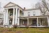
James Noble Sherwood House |
|
000000001984-12-27-0000December 27, 1984
(#84000507) |
768 Riverview Dr.
42°25′55″N 85°37′09″W / 42.431944°N 85.619167°W / 42.431944; -85.619167 (James Noble Sherwood House) |
Plainwell |
|
| 31 |
Sarah Lowe Stedman House |
|
000000001987-03-12-0000March 12, 1987
(#87000266) |
632 Grand St.
42°31′59″N 85°50′05″W / 42.533056°N 85.834722°W / 42.533056; -85.834722 (Sarah Lowe Stedman House) |
Allegan |
|
| 32 |
Warner P. Sutton House |
|
000000001992-01-22-0000January 22, 1992
(#91001999) |
736 Pleasant St.
42°39′13″N 86°11′47″W / 42.653611°N 86.196389°W / 42.653611; -86.196389 (Warner P. Sutton House) |
Saugatuck |
|
| 33 |
West Bridge Street Historic District |
|
000000001991-11-01-0000November 1, 1991
(#91001549) |
320, 414-550 and 321-563 W. Bridge St.
42°26′32″N 85°38′57″W / 42.442222°N 85.649167°W / 42.442222; -85.649167 (West Bridge Street Historic District) |
Plainwell |
|


.jpg)