National Register of Historic Places listings in Muskegon County, Michigan
The following is a list of Registered Historic Places in Muskegon County, Michigan.
- This National Park Service list is complete through NPS recent listings posted December 16, 2016.[1]
| [2] | Name on the Register[3] | Image | Date listed[4] | Location | City or town | Description |
|---|---|---|---|---|---|---|
| 1 | Amazon Hosiery Mill | 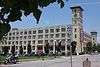 |
(#82002857) |
530-550 W. Western Ave. 43°14′01″N 86°15′25″W / 43.233611°N 86.256944°W |
Muskegon | |
| 2 | Central Fire Station |  |
(#99000341) |
75 W. Walton Ave. 43°14′04″N 86°14′44″W / 43.234444°N 86.245556°W |
Muskegon | |
| 3 | Charles H. Hackley House | 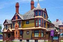 |
(#70000282) |
484 W. Webster Ave. 43°13′53″N 86°15′32″W / 43.231389°N 86.258889°W |
Muskegon | |
| 4 | Horatio N. Hovey House | 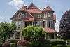 |
(#83000887) |
318 Houston Ave. 43°13′53″N 86°15′05″W / 43.231389°N 86.251389°W |
Muskegon | |
| 5 | Hume House | 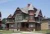 |
(#72000646) |
472 W. Webster Ave. 43°13′53″N 86°15′32″W / 43.231389°N 86.258889°W |
Muskegon | |
| 6 | John C. and Augusta (Covell) Lewis House | 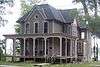 |
(#10001027) |
324 S. Mears Ave. 43°24′25″N 86°20′52″W / 43.406944°N 86.347778°W |
Whitehall | |
| 7 | Muskegon Historic District | 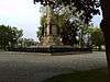 |
(#72000647) |
Bounded roughly by Clay, Muskegon, 2nd, and 6th Sts. 43°14′00″N 86°15′15″W / 43.233333°N 86.254167°W |
Muskegon | |
| 8 | Muskegon South Breakwater Light | 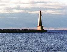 |
(#06001026) |
At south breakwater end in Lake Michigan, 0.4 mi (0.64 km). SW of Muskegon Lake entry channel 43°13′26″N 86°20′48″W / 43.223889°N 86.346667°W |
Muskegon | |
| 9 | Muskegon South Pierhead Light | |
(#06000036) |
Southern pier of the Muskegon Lake entrance channel at Lake Michigan, 500 ft (150 m) from shore 43°13′36″N 86°20′29″W / 43.226667°N 86.341389°W |
Muskegon | |
| 10 | Muskegon YMCA Building | 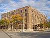 |
(#82002858) |
297 W. Clay Ave. 43°14′07″N 86°15′02″W / 43.235278°N 86.250556°W |
Muskegon | |
| 11 | Navigation Structures at White Lake Harbor | 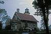 |
(#00000535) |
Southern end of Lau Rd. 43°22′31″N 86°25′34″W / 43.375278°N 86.426111°W |
Whitehall | |
| 12 | Spring Creek Site |  |
(#72001475) |
Address Restricted |
Unknown | |
| 13 | SS CLIPPER | |
(#83003570) |
2098 Lakeshore Dr.[5] 43°13′18″N 86°17′45″W / 43.2218°N 86.2959°W |
Muskegon | |
| 14 | U.S.S. SILVERSIDES | 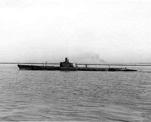 |
(#72000453) |
Naval Reserve Center, Fulton and Bluff Sts. 43°13′39″N 86°20′19″W / 43.2275°N 86.338611°W |
Muskegon | |
| 15 | Union Depot | 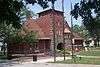 |
(#00001489) |
610 Western Ave. 43°13′59″N 86°15′28″W / 43.233056°N 86.257778°W |
Muskegon |
See also
| Wikimedia Commons has media related to National Register of Historic Places in Muskegon County, Michigan. |
- List of Registered Historic Places in Michigan
- List of Michigan State Historic Sites in Muskegon County, Michigan
References
- ↑ "National Register of Historic Places: Weekly List Actions". National Park Service, United States Department of the Interior. Retrieved on December 16, 2016.
- ↑ Numbers represent an ordering by significant words. Various colorings, defined here, differentiate National Historic Landmarks and historic districts from other NRHP buildings, structures, sites or objects.
- ↑ National Park Service (2008-04-24). "National Register Information System". National Register of Historic Places. National Park Service.
- ↑ The eight-digit number below each date is the number assigned to each location in the National Register Information System database, which can be viewed by clicking the number.
- ↑ Location derived from this Clipper-associated website; the NRIS still lists it in its old location of Hammond, Indiana
| Lists by county |
|   |
|---|---|---|
| Other lists |
| |
| Topics | |
|---|---|
| Lists by states |
|
| Lists by insular areas | |
| Lists by associated states | |
| Other areas | |
| |
This article is issued from Wikipedia - version of the 5/17/2016. The text is available under the Creative Commons Attribution/Share Alike but additional terms may apply for the media files.