National Register of Historic Places listings in Benton County, Washington
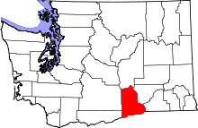
Location of Benton County in Washington
This list presents the full set of buildings, structures, objects, sites, or districts designated on the National Register of Historic Places in Benton County, Washington, and offers brief descriptive information about each of them. The National Register recognizes places of national, state, or local historic significance across the United States.[1] Out of over 90,000 National Register sites nationwide,[2] Washington is home to approximately 1,500,[3] and 15 of those are found partially or wholly in Benton County.
- This National Park Service list is complete through NPS recent listings posted November 25, 2016.[4]
Current listings
| [5] | Name on the Register | Image | Date listed[6] | Location | City or town | Description |
|---|---|---|---|---|---|---|
| 1 | Benton County Courthouse |  |
(#76001869) |
Dudley Ave. and Market St. 46°12′12″N 119°46′10″W / 46.203333°N 119.769444°W |
Prosser | |
| 2 | J. W. Carey House |  |
(#89002096) |
Byron Rd., W of Prosser 46°11′45″N 119°48′05″W / 46.195833°N 119.801389°W |
Prosser | |
| 3 | Glade Creek Site | Upload image | (#77001330) |
Address restricted[7] |
Prosser | |
| 4 | Gold Coast Historic District |  |
(#04000315) |
Roughly bounded by Willis St., Davison Ave., Hunt Ave., Davison Ave., and George Washington Way 46°17′53″N 119°16′12″W / 46.298056°N 119.27°W |
Richland | |
| 5 | Hanford B Reactor | 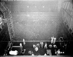 |
(#92000245) |
Near jct. of WA 24 and WA 240, Hanford Site 46°37′50″N 119°38′46″W / 46.630556°N 119.646111°W |
Richland | Designated a National Historic Landmark August 19, 2008 |
| 6 | Hanford Island Archeological Site | 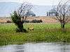 |
(#76001870) |
Address restricted[7] |
Richland | |
| 7 | Hanford North Archeological District | Upload image | (#76001871) |
Address restricted[7] |
Richland | |
| 8 | Locke Island Archeological District | Upload image | (#76001872) |
Address restricted[7] |
Richland | |
| 9 | Rattlesnake Springs Sites | Upload image | (#76001873) |
Address restricted[7] |
Richland | |
| 10 | Ryegrass Archeological District | Upload image | (#76001874) |
Address restricted[7] |
Richland | |
| 11 | Snively Canyon Archeological District | Upload image | (#76001875) |
Address restricted[7] |
Richland | |
| 12 | Telegraph Island Petroglyphs | Upload image | (#75001840) |
Address restricted[7] |
Paterson | |
| 13 | Tri-Cities Archaeological District | Upload image | (#84000468) |
Address restricted[7] |
Kennewick | |
| 14 | U.S. Post Office – Prosser Main | 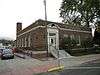 |
(#91000653) |
1103 Meade Ave. 46°12′15″N 119°46′09″W / 46.204167°N 119.769167°W |
Prosser | |
| 15 | Wooded Island Archeological District | Upload image | (#76001876) |
Address restricted[7] |
Richland |
Former listings
| [5] | Name on the Register | Image | Date listed | Date removed | Location | City or town | Summary |
|---|---|---|---|---|---|---|---|
| 1 | Prosser Steel Bridge | Upload image | (#82004195) | Spans Yakima River |
Prosser |
See also
- National Register of Historic Places listings in Washington state
- Listings in neighboring counties: Franklin, Grant, Klickitat, Morrow, Umatilla, Walla Walla, Yakima
- List of National Historic Landmarks in Washington (state)
- Historic preservation
- History of Washington (state)
- Index of Washington-related articles
References
- ↑ Andrus, Patrick W.; Shrimpton, Rebecca H.; et al. (2002), How to Apply the National Register Criteria for Evaluation, National Register Bulletin (15), National Park Service, U.S. Department of the Interior, retrieved June 20, 2014.
- ↑ National Park Service, National Register of Historic Places Program: Research, retrieved January 28, 2015.
- ↑ Department of Archaeology and Historic Preservation, Washington Information System for Architectural and Archaeological Records Data (WISAARD), retrieved February 14, 2015.
- ↑ "National Register of Historic Places: Weekly List Actions". National Park Service, United States Department of the Interior. Retrieved on November 25, 2016.
- 1 2 Numbers represent an ordering by significant words. Various colorings, defined here, differentiate National Historic Landmarks and historic districts from other NRHP buildings, structures, sites or objects.
- ↑ The eight-digit number below each date is the number assigned to each location in the National Register Information System database, which can be viewed by clicking the number.
- 1 2 3 4 5 6 7 8 9 10 Federal and state laws and practices restrict general public access to information regarding the specific location of sensitive archeological sites in many instances. The main reasons for such restrictions include the potential for looting, vandalism, or trampling. See: Knoerl, John; Miller, Diane; Shrimpton, Rebecca H. (1990), Guidelines for Restricting Information about Historic and Prehistoric Resources, National Register Bulletin (29), National Park Service, U.S. Department of the Interior, OCLC 20706997.
External links
- Washington Department of Archaeology and Historic Preservation, Historic Register program
- National Park Service, National Register of Historic Places site
 Media related to National Register of Historic Places in Benton County, Washington at Wikimedia Commons

| Topics | |
|---|---|
| Lists by states |
|
| Lists by insular areas | |
| Lists by associated states | |
| Other areas | |
| |
Municipalities and communities of Benton County, Washington, United States | ||
|---|---|---|
| Cities | | |
| CDPs | ||
| Unincorporated communities | ||
| Unincorporated communities | ||
This article is issued from Wikipedia - version of the 1/18/2016. The text is available under the Creative Commons Attribution/Share Alike but additional terms may apply for the media files.