National Register of Historic Places listings in Bolivar County, Mississippi
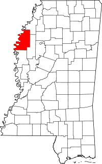
Location of Bolivar County in Mississippi
This is a list of the National Register of Historic Places listings in Bolivar County, Mississippi.
This is intended to be a complete list of the properties and districts on the National Register of Historic Places in Bolivar County, Mississippi, United States. Latitude and longitude coordinates are provided for many National Register properties and districts; these locations may be seen together in a map.[1]
There are 14 properties and districts listed on the National Register in the county, including 1 National Historic Landmark.
- This National Park Service list is complete through NPS recent listings posted December 16, 2016.[2]
Current listings
| [3] | Name on the Register[4] | Image | Date listed[5] | Location | City or town | Description |
|---|---|---|---|---|---|---|
| 1 | Adath Israel Temple | 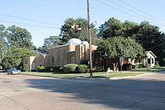 |
(#02001499) |
201 S. Bolivar Ave. 33°44′34″N 90°43′28″W / 33.742778°N 90.724444°W |
Cleveland | |
| 2 | Alligator Mounds | Upload image | (#74001056) |
Northwestern quarter of the northeastern quarter of Section 32, Township 26 North, Range 5 West[6] 34°05′26″N 90°44′14″W / 34.090556°N 90.737222°W |
Alligator | |
| 3 | Cleveland Founders Historic District | Upload image | (#07001179) |
Roughly bounded by Victoria Ave., Sunflower Rd., Bolivar Ave., S. Bayou Ave., and Avery St. 33°44′42″N 90°43′35″W / 33.7450°N 90.7263°W |
Cleveland | |
| 4 | Donelson House | Upload image | (#76001091) |
2.5 miles southwest of Duncan 34°01′35″N 90°46′46″W / 34.026389°N 90.779444°W |
Duncan | |
| 5 | Downtown Cleveland Historic District | 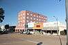 |
(#98001332) |
Roughly bounded by Bolivar Ave., 1 block north of 1st St., Commerce Ave., and Collins St.; also 201 S. Court St. and 200-215 N. Pearman Ave. 33°44′54″N 90°43′21″W / 33.748333°N 90.7225°W |
Cleveland | Court and Pearman addresses represent a boundary increase of July 7, 2003 |
| 6 | Grace Episcopal Church | 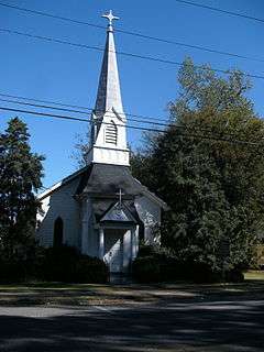 |
(#80002202) |
203 Main St. 33°51′22″N 91°01′38″W / 33.856111°N 91.027222°W |
Rosedale | |
| 7 | Hollywood | .jpg) |
(#75001041) |
South of Benoit on Mississippi Highway 448 33°38′23″N 91°00′17″W / 33.639722°N 91.004722°W |
Benoit | |
| 8 | I. T. Montgomery House | .jpg) |
(#76001092) |
W. Main St. 33°52′37″N 90°43′44″W / 33.876944°N 90.728889°W |
Mound Bayou | |
| 9 | Mound Bayou Bank | Upload image | (#96000187) |
W. Main St. 33°52′32″N 90°43′43″W / 33.875556°N 90.728611°W |
Mound Bayou | |
| 10 | Mound Bayou Historic District | Upload image | (#13000735) |
Roughly bounded by Martin Luther King Ave., Mound Bayou Cemetery, South & Davis Sts. 33°52′42″N 90°43′49″W / 33.8784°N 90.7302°W |
Mound Bayou | |
| 11 | Rosedale Historic District | Upload image | (#00000331) |
Roughly along Main, Front, and Levee Sts., from Elizabeth Ave. to Brown St. 33°51′27″N 91°01′41″W / 33.8575°N 91.028056°W |
Rosedale | |
| 12 | Walter Sillers Sr. House | Upload image | (#97000252) |
307 Levee St. 33°51′34″N 91°01′50″W / 33.859444°N 91.030556°W |
Rosedale | |
| 13 | Taborian Hospital | Upload image | (#96000827) |
U.S. Route 61 at its junction with McGinnis St. 33°52′48″N 90°43′36″W / 33.88°N 90.726667°W |
Mound Bayou | |
| 14 | U.S. Post Office | Upload image | (#81000326) |
301 S. Sharpe Ave. 33°44′32″N 90°43′18″W / 33.742222°N 90.721667°W |
Cleveland | Now a police station. |
See also
| Wikimedia Commons has media related to National Register of Historic Places in Bolivar County, Mississippi. |
- List of National Historic Landmarks in Mississippi
- National Register of Historic Places listings in Mississippi
References
- ↑ The latitude and longitude information provided in this table was derived originally from the National Register Information System, which has been found to be fairly accurate for about 99% of listings. For about 1% of NRIS original coordinates, experience has shown that one or both coordinates are typos or otherwise extremely far off; some corrections may have been made. A more subtle problem causes many locations to be off by up to 150 yards, depending on location in the country: most NRIS coordinates were derived from tracing out latitude and longitudes off of USGS topographical quadrant maps created under the North American Datum of 1927, which differs from the current, highly accurate WGS84 GPS system used by most on-line maps. Chicago is about right, but NRIS longitudes in Washington are higher by about 4.5 seconds, and are lower by about 2.0 seconds in Maine. Latitudes differ by about 1.0 second in Florida. Some locations in this table may have been corrected to current GPS standards.
- ↑ "National Register of Historic Places: Weekly List Actions". National Park Service, United States Department of the Interior. Retrieved on December 16, 2016.
- ↑ Numbers represent an ordering by significant words. Various colorings, defined here, differentiate National Historic Landmarks and historic districts from other NRHP buildings, structures, sites or objects.
- ↑ National Park Service (2009-03-13). "National Register Information System". National Register of Historic Places. National Park Service.
- ↑ The eight-digit number below each date is the number assigned to each location in the National Register Information System database, which can be viewed by clicking the number.
- ↑ Phillips, Philip, et al. Archaeological Survey in the Lower Mississippi Alluvial Valley 1940-1947. Reprint ed. Tuscaloosa: U of Alabama P, 2003, 53.
| Topics | |
|---|---|
| Lists by states |
|
| Lists by insular areas | |
| Lists by associated states | |
| Other areas | |
| |
Municipalities and communities of Bolivar County, Mississippi, United States | ||
|---|---|---|
| Cities | | |
| Towns | ||
| Unincorporated communities | ||
| Ghost towns | ||
| Footnotes | ‡This populated place also has portions in an adjacent county or counties | |
This article is issued from Wikipedia - version of the 10/28/2016. The text is available under the Creative Commons Attribution/Share Alike but additional terms may apply for the media files.