National Register of Historic Places listings in Bonner County, Idaho
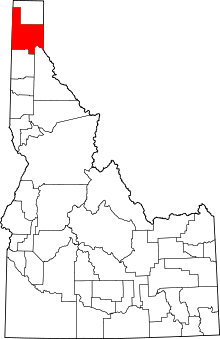
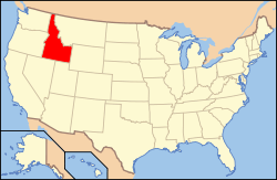
Location of Bonner County in Idaho
This is a list of the National Register of Historic Places listings in Bonner County, Idaho.
This is intended to be a complete list of the properties and districts on the National Register of Historic Places in Bonner County, Idaho, United States. Latitude and longitude coordinates are provided for many National Register properties and districts; these locations may be seen together in a Google map.[1]
There are 16 properties and districts listed on the National Register in the county. More may be added; properties and districts nationwide are added to the Register weekly.[2]
- This National Park Service list is complete through NPS recent listings posted December 16, 2016.[3]
Current listings
| [4] |
Name on the Register[5] |
Image |
Date listed[6] |
Location |
City or town |
Description |
|---|
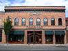
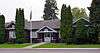
| 1 |
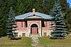
W. A. Bernd Building |
|
000000001983-08-18-0000August 18, 1983
(#83000282) |
307–311 N. 1st Ave.
48°16′31″N 116°32′53″W / 48.275301°N 116.548092°W / 48.275301; -116.548092 (W. A. Bernd Building) |
Sandpoint |
|
| 2 |
Dover Church |
|
000000001989-08-08-0000August 8, 1989
(#86002153) |
Washington Ave. between 3rd and 4th Sts.
48°14′53″N 116°36′22″W / 48.248120°N 116.606078°W / 48.248120; -116.606078 (Dover Church) |
Dover |
|
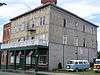
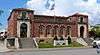
| 3 |
Hotel Charbonneau |
|
000000001991-11-19-0000November 19, 1991
(#91001718) |
88 Wisconsin St.
48°10′45″N 116°54′32″W / 48.179244°N 116.908928°W / 48.179244; -116.908928 (Hotel Charbonneau) |
Priest River |
|
| 4 |
Lamb Creek School |
Upload image |
000000001999-11-30-0000November 30, 1999
(#99001418) |
28769 N. Highway 57
48°31′34″N 116°56′20″W / 48.526122°N 116.938850°W / 48.526122; -116.938850 (Lamb Creek School) |
Priest River vicinity |
|
| 5 |
Amanda Nesbitt House |
Upload image |
000000001982-07-15-0000July 15, 1982
(#82002508) |
602 N. 4th Ave.
48°16′42″N 116°33′05″W / 48.278405°N 116.551512°W / 48.278405; -116.551512 (Amanda Nesbitt House) |
Sandpoint |
|
| 6 |
Charles A. and Mary Olson House |
Upload image |
000000002001-05-30-0000May 30, 2001
(#01000566) |
401 Church St.
48°16′26″N 116°33′08″W / 48.273795°N 116.552151°W / 48.273795; -116.552151 (Charles A. and Mary Olson House) |
Sandpoint |
|
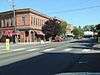
| 7 |
Priest River Commercial Core Historic District |
Upload image |
000000001995-08-31-0000August 31, 1995
(#95001057) |
Roughly bounded by Wisconsin, Montgomery, and Cedar Sts. and Albeni Rd.
48°10′45″N 116°54′27″W / 48.179133°N 116.907457°W / 48.179133; -116.907457 (Priest River Commercial Core Historic District) |
Priest River |
|
| 8 |
Priest River Experimental Forest |
Upload image |
000000001994-07-01-0000July 1, 1994
(#94000661) |
Idaho Panhandle National Forest
48°21′09″N 116°47′49″W / 48.3525°N 116.796944°W / 48.3525; -116.796944 (Priest River Experimental Forest) |
Sandpoint |
|
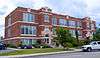
| 9 |
Priest River High School |
|
000000001995-12-07-0000December 7, 1995
(#95001402) |
1020 W. Albeni Rd.
48°10′52″N 116°55′07″W / 48.181029°N 116.918717°W / 48.181029; -116.918717 (Priest River High School) |
Priest River |
Building is used by Priest River Junior High
|
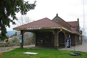
| 10 |
Sandpoint Burlington Northern Railway Station |
|
000000001973-07-05-0000July 5, 1973
(#73000682) |
Cedar St. at Sand Creek
48°16′35″N 116°32′44″W / 48.276416°N 116.545631°W / 48.276416; -116.545631 (Sandpoint Burlington Northern Railway Station) |
Sandpoint |
|
| 11 |
Sandpoint Community Hall |
|
000000001986-09-11-0000September 11, 1986
(#86002148) |
204 S. 1st Ave.
48°16′18″N 116°32′53″W / 48.271574°N 116.548144°W / 48.271574; -116.548144 (Sandpoint Community Hall) |
Sandpoint |
|
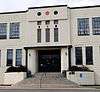
| 12 |
Sandpoint Federal Building |
|
000000002001-08-08-0000August 8, 2001
(#01000836) |
419 N. 2nd Ave.
48°16′37″N 116°32′57″W / 48.276919°N 116.549084°W / 48.276919; -116.549084 (Sandpoint Federal Building) |
Sandpoint |
|
| 13 |
Sandpoint High School |
|
000000001999-10-28-0000October 28, 1999
(#99001277) |
102 S. Euclid Ave.
48°16′21″N 116°33′17″W / 48.272582°N 116.554650°W / 48.272582; -116.554650 (Sandpoint High School) |
Sandpoint |
Currently the Sandpoint Events Center
|
| 14 |
Sandpoint Historic District |
|
000000001984-09-07-0000September 7, 1984
(#84001100) |
Roughly 1st and 2nd Aves. and Main and Cedar Sts.
48°16′32″N 116°32′54″W / 48.275439°N 116.548325°W / 48.275439; -116.548325 (Sandpoint Historic District) |
Sandpoint |
|
| 15 |
Settlement School |
|
000000001999-04-01-0000April 1, 1999
(#99000418) |
Settlement Rd., 0.5 miles east of its junction with E. Side Rd.
48°10′55″N 116°52′28″W / 48.182035°N 116.874565°W / 48.182035; -116.874565 (Settlement School) |
Priest River |
|
| 16 |
Vinther and Nelson Cabin |
Upload image |
000000001982-07-21-0000July 21, 1982
(#82002507) |
Eightmile Island
48°34′47″N 116°50′19″W / 48.579604°N 116.838484°W / 48.579604; -116.838484 (Vinther and Nelson Cabin) |
Coolin vicinity |
|
See also
References
- ↑ The latitude and longitude information provided in this table was derived originally from the National Register Information System, which has been found to be fairly accurate for about 99% of listings. For about 1% of NRIS original coordinates, experience has shown that one or both coordinates are typos or otherwise extremely far off; some corrections may have been made. A more subtle problem causes many locations to be off by up to 150 yards, depending on location in the country: most NRIS coordinates were derived from tracing out latitude and longitudes off of USGS topographical quadrant maps created under the North American Datum of 1927, which differs from the current, highly accurate WGS84 GPS system used by most on-line maps. Chicago is about right, but NRIS longitudes in Washington are higher by about 4.5 seconds, and are lower by about 2.0 seconds in Maine. Latitudes differ by about 1.0 second in Florida. Some locations in this table may have been corrected to current GPS standards.
- ↑ "National Register of Historic Places: Weekly List Actions". National Park Service. Retrieved March 29, 2009.
- ↑ "National Register of Historic Places: Weekly List Actions". National Park Service, United States Department of the Interior. Retrieved on December 16, 2016.
- ↑ Numbers represent an ordering by significant words. Various colorings, defined here, differentiate National Historic Landmarks and historic districts from other NRHP buildings, structures, sites or objects.
- ↑ National Park Service (2008-04-24). "National Register Information System". National Register of Historic Places. National Park Service.
- ↑ The eight-digit number below each date is the number assigned to each location in the National Register Information System database, which can be viewed by clicking the number.
|
|---|
|
| Topics | |
|---|
|
| Lists by states | |
|---|
|
| Lists by insular areas | |
|---|
|
| Lists by associated states | |
|---|
|
| Other areas | |
|---|
|
-
 Portal Portal
-
 WikiProject WikiProject
|